The Challenge
Climate change is proposed to have a significant impact on crop yields and the life cycle of pests and diseases. Increased temperature conditions and erratic rainfall patterns are the aftermath of climate change that greatly affects crops.
In early April 2025, Dunsfield Farms identified a severe case of fall armyworm (FAW) infestation across its maize fields. Farmers observed common signs of FAW damage. The infestation was rapidly spreading across multiple plots.
While the full extent of damage is still under assessment, about 10 hectares of the maize field have been affected. To respond effectively, we grounded our approach in the pest’s biology to enable a more targeted and timely intervention.
The Fall Armyworm (FAW) is scientifically known as Spodoptera Frugiperda, an invasive pest native to tropical regions of the Americas. Females produce approximately 1,000 eggs in clusters on leaves. At larva stage, it feeds on its host by damaging the leaves and boring holes into maize cobs. When fully matured, the adult moth can fly up to 100km per night (CABI(2020)), migrating and reproducing in multiple places.
Fall armyworm can cause up to 50% yield loss in untreated maize fields in Nigeria (FAO, 2019), and aside from maize, it affects other crops like sorghum, rice, sugarcane, cotton, and vegetables (cabbage, tomatoes).
Without swift intervention, infestations like these can wipe out entire crops within weeks.
Why Traditional Methods Failed
The fall armyworm outbreak started during the vegetative stage of maize growth. At this stage, damage to leaves significantly reduces the plant's ability to photosynthesize, thereby increasing the risk of substantial yield loss.
Prior methods of combating this infestation, using knapsack sprayers, were too slow, labor-intensive, and inconsistent for the scale and urgency of the outbreak. Other preventive measures, such as early-season planting and basic pesticide application, were insufficient against the intensity of this year’s infestation.
Our Solution
The need for an intervention using precision agriculture methods—drones—to first monitor the extent of the damage proved to be a viable option for a faster, more targeted solution.
Our expertise in drone-based crop scouting and aerial spraying offers an accurate and scalable alternative. Though more expensive upfront, drone deployment reduces application time up to 75%, ensures uniform coverage, reduces exposure of farmers to harmful pesticides, and gives detailed insights for making informed decisions.
To address the fast-spreading infestation, we deployed a two-stage intervention:
Plant Health Assessment with DJI Mavic 3 Multispectral Drone
We conducted an initial aerial survey using the DJI Mavic 3 Multispectral drone to assess plant health across the affected field.
To properly assess the severity of the damage, multispectral images are more effective than RGB images. While RGB imagery provides a general visual overview, multispectral images give a more detailed analysis, capturing spectral information that is invisible to the naked eye. They help detect subtle changes in plant reflection like stress, chlorophyll, and early pest damage.
The options for analysis with multispectral images also offer more insights, calculating values from different spectral bands (green, red, red edge and near-infrared), and for this study we compared results from NDVI and NDRE analysis.
NDRE vs NDVI
NDVI is a popular and widely accepted vegetation indices that’s commonly used to assess pest infestation provided a general overview of vegetation health, while NDRE offered more granular insight into chlorophyll levels.
Interestingly, NDRE revealed early-stage stress patterns in sections of the field that appeared healthy under NDVI, particularly in plots where armyworm feeding had eaten deep. This discrepancy between indices confirmed the importance of red-edge analysis for early pest detection.
Here’s how we know which vegetation index was more effective at showing the damage done by FAW
NDVI (Normalized Difference Vegetation Index)
NDRE (Normalized Difference Red Edge Index)
Measures overall greenness, photosynthetic activity using the R and NIR band
Calculated using the red-edge band (between red and NIR) and NIR
Good for general plant health detection
Detects subtle changes in chlorophyll content
Can be less sensitive to early stress or internal damage
More sensitive to early-stage stress, internal crop health, and can detect stress before it becomes visible
These images explain which vegetation index was more effective at showing the damage done by FAW:
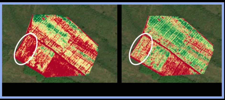
Fall armyworm affects chlorophyll through leaf feeding damage before visible wilting or yellowing occurs. NDRE is better at picking up these early physiological changes in the plants making it more effective for early scouting and precision intervention.
Precision Spraying with DJI Agras T50
Using insights from the scouting phase, we proceeded with drone-based insecticide application using the DJI Agras T50. The spraying was targeted, fast, and uniform—covering large areas in a fraction of the time it would take with manual labour, and minimizing pesticide waste. This rapid response helped contain the spread and prevent further crop loss.
The Dunsfield Farms intervention is a clear reminder that pest outbreaks like fall armyworm demand more than just reactive measures—they require speed, precision, and data-driven action. What began as a worsening infestation became an opportunity to demonstrate the power of integrated drone solutions: multispectral crop scouting for early detection, and targeted aerial spraying for rapid containment.
Our use of NDRE helped uncover stress signals that traditional scouting and even NDVI overlooked—proof that deeper insights lead to smarter decisions. By pairing advanced monitoring with fast-response drone spraying, we helped the client take back control—saving what could have easily been a failed season.