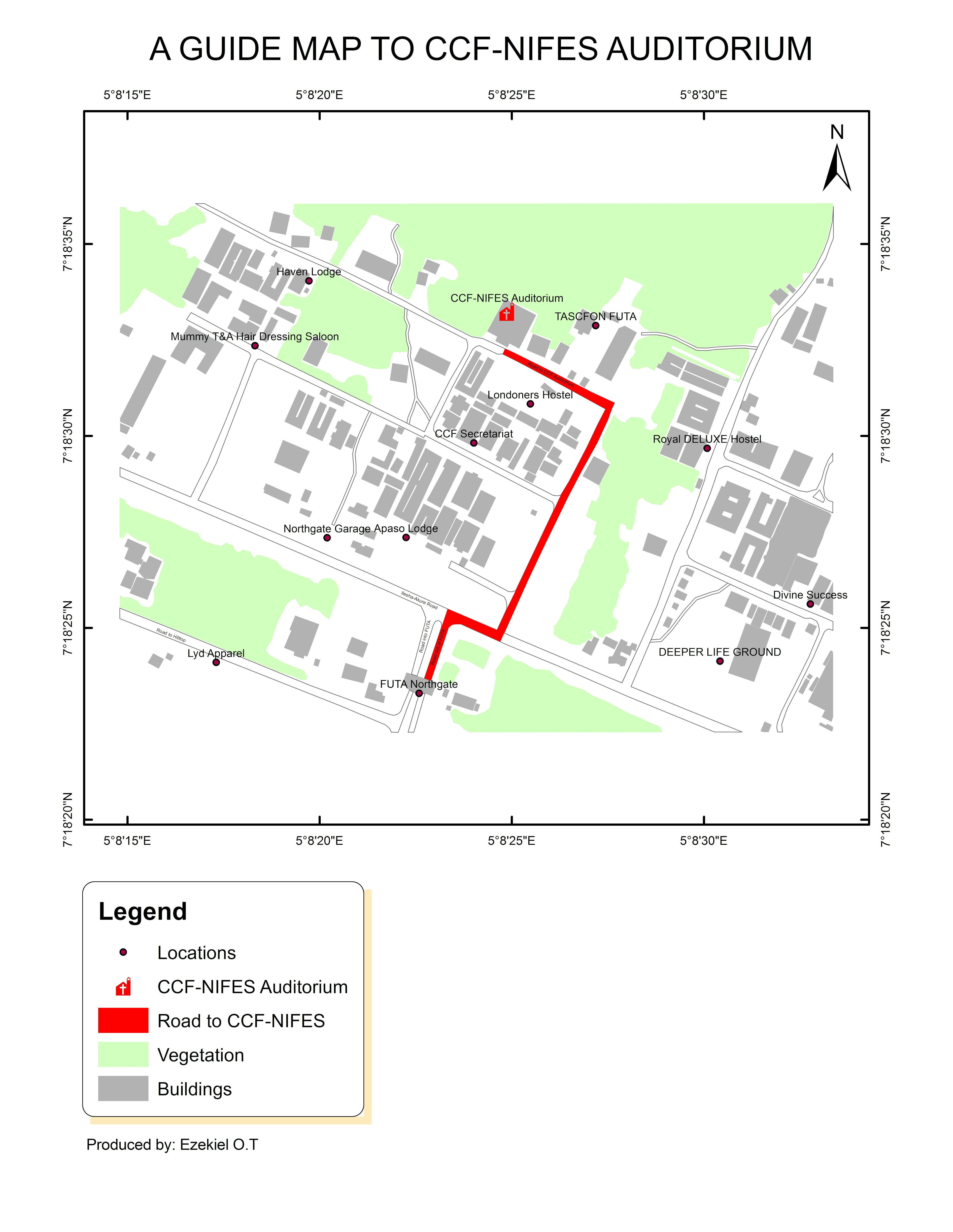
Description
Pathix is a simple concept that surrounds the idea of producing a detailed guide map with the aim of communicating the path to a certain geographic location in concern. It is designed to direct a stranger to a location in an environment or society he/she has never been to before.
The idea is to capture the destination and a nearby well known bustop and then produce a map that will guide anyone, every step of the way. The idea also reduces the asking of questions from people in an area about the location in concern, thereby increasing the level of security.
In contrast to Google map app, which requires an online access to navigate oneself in a geographic region, pathix is a static offline digital map that can be accessed via the gallery of any mobile device. Also, pathix does not cover a large geographic region and does not keep track of ones immediate location.
Tools used
- ArcMap 10.8
- Google Earth engine
Procedures
Data gathering
- A landscape image was captured using Google Earth engine. This image has both the nearby bustop and the location in concern captured and visible in it. It was downloaded in the jpg format. It represents the raster data needed for the project.
- Four coordinate points were picked and recorded also, each of which are close to the four vertexes of the image respectively, to aid a precise georeferenced work.
Georeferencing and Digitizing
- The raster data was imported into arcmap
- The geographic coordinate reference system(GCS) was used... WGS 1984 precisely
- The raster data was georeferenced using the georeferencing tools
- Three major features were digitized... The roads, buildings and vegetation
- The major road/path, linking the bustop (FUTA North gate) and the destination (CCF-NIFES) is highlighted in red color for emphasis sake
- The finishing of the map was done in the layout view and further exported in an image format
Geoprocessing
- All the roads were dissolved into one layer, but still had their names retained in the attribute table. This was done to avoid overlapping of one road on the other.
Study area
- CCF-NIFES stands for Campus Christian Fellowship - Nigerian Fellowship of Evangelical Students.
- CCF-NIFES auditorium: The auditorium is about 500metres away from the bustop.