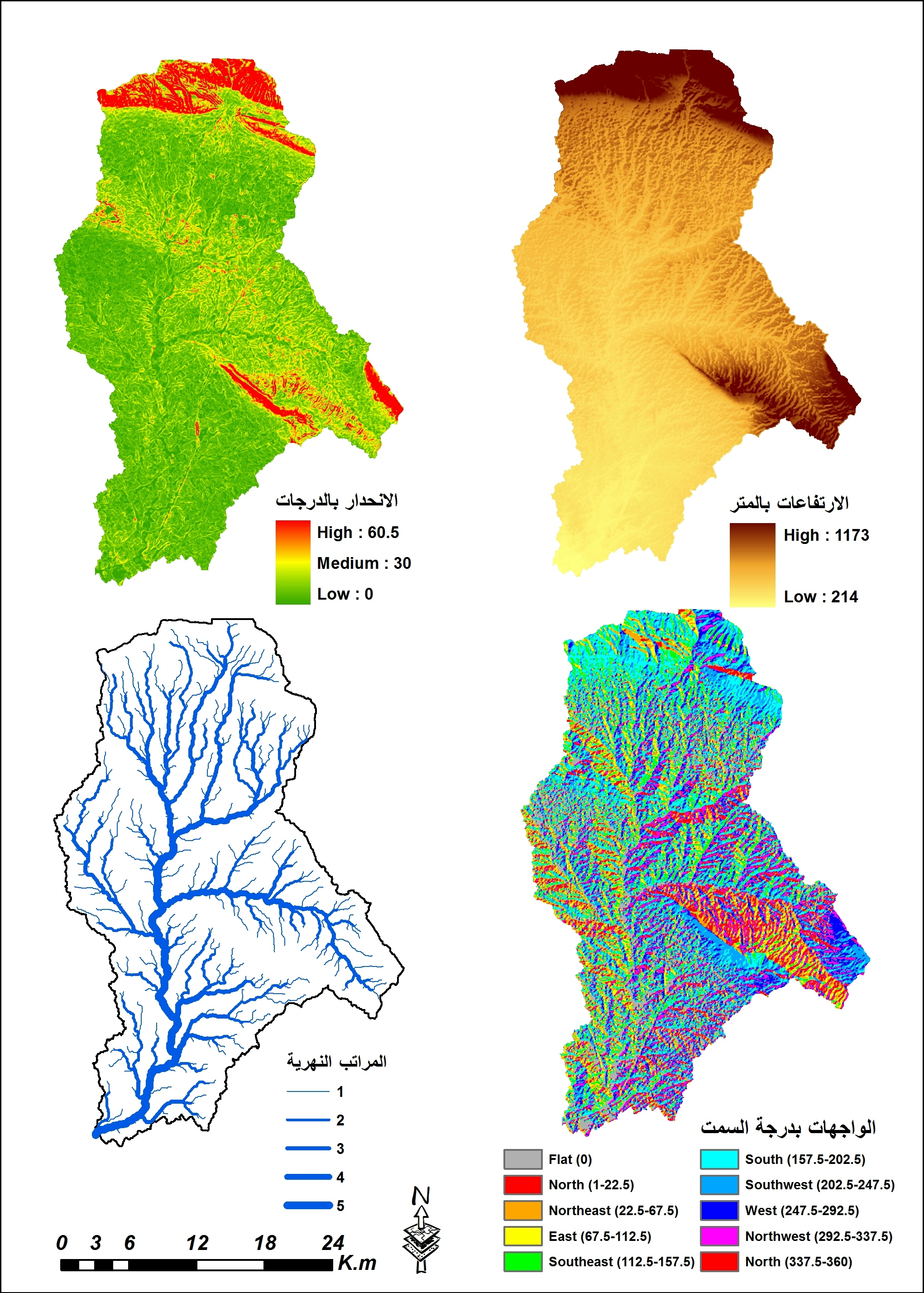
Sign up or log in to your Spatialnode account.

Takes less than a few seconds.

Alcoser watershed

Aahed Alhamamy
Aahed Alhamamy•

January 23, 2022

Alcoser watershed

Tools used

ArcMapGlobal mapper

More by Aahed Alhamamy

Gully Erosion in Alcoser watershed
179

You might also like

Nebraska Irrigation Well
Keran Nkongolo
Nebraska Irrigation Well
Keran NkongoloPro
22
PCPs per 100k Residents in Canada
Meredith McKinney
PCPs per 100k Residents in Canada
Meredith McKinney
24
Mapa de uso e ocupação do solo
Amanda Ellen da Silva Conceição
Mapa de uso e ocupação do solo
Amanda Ellen...
50
Predicting Floods with Unit Hydrographs
Miranda Teats
Predicting Floods with Unit Hydrographs
Miranda Teats
54
Evolução temporal do IDHM em MS
Raimundo Junior
Evolução temporal do IDHM em MS
Raimundo Junior
6
A story map about Frenchy, my dog
All That Geo
A story map about Frenchy, my dog
All That Geo
179
Sharp Park Golf Course Changes
Timothy Brink
Sharp Park Golf Course Changes
Timothy BrinkPro
92
EGNOS TRAN - Maritime
Kareen Bröker
EGNOS TRAN - Maritime
Kareen Bröker
22
Bathymetry of Lake Geneva
Adriana Calderon
Bathymetry of Lake Geneva
Adriana Calderon
105
New Features Update
Spatialnode
New Features Update
SpatialnodePro+
136
Percentage of tree canopy cover (PCA)
Matheus Medici
Percentage of tree canopy cover (PCA)
Matheus Medici
25
Australia Wheat & Precipitation 2022
Keran Nkongolo
Australia Wheat & Precipitation 2022
Keran NkongoloPro
13

Join the community!

We're a place where geospatial professionals showcase their works and discover opportunities.

Sign Up for free