Sign up or log in to your Spatialnode account.

Takes less than a few seconds.

ÍNDICE DE VULNERABILIDADE SOCIOAMBIENTAL

Francielle Caminhas
Francielle Caminhas•

March 23, 2022

ÍNDICE DE VULNERABILIDADE SOCIOAMBIENTAL

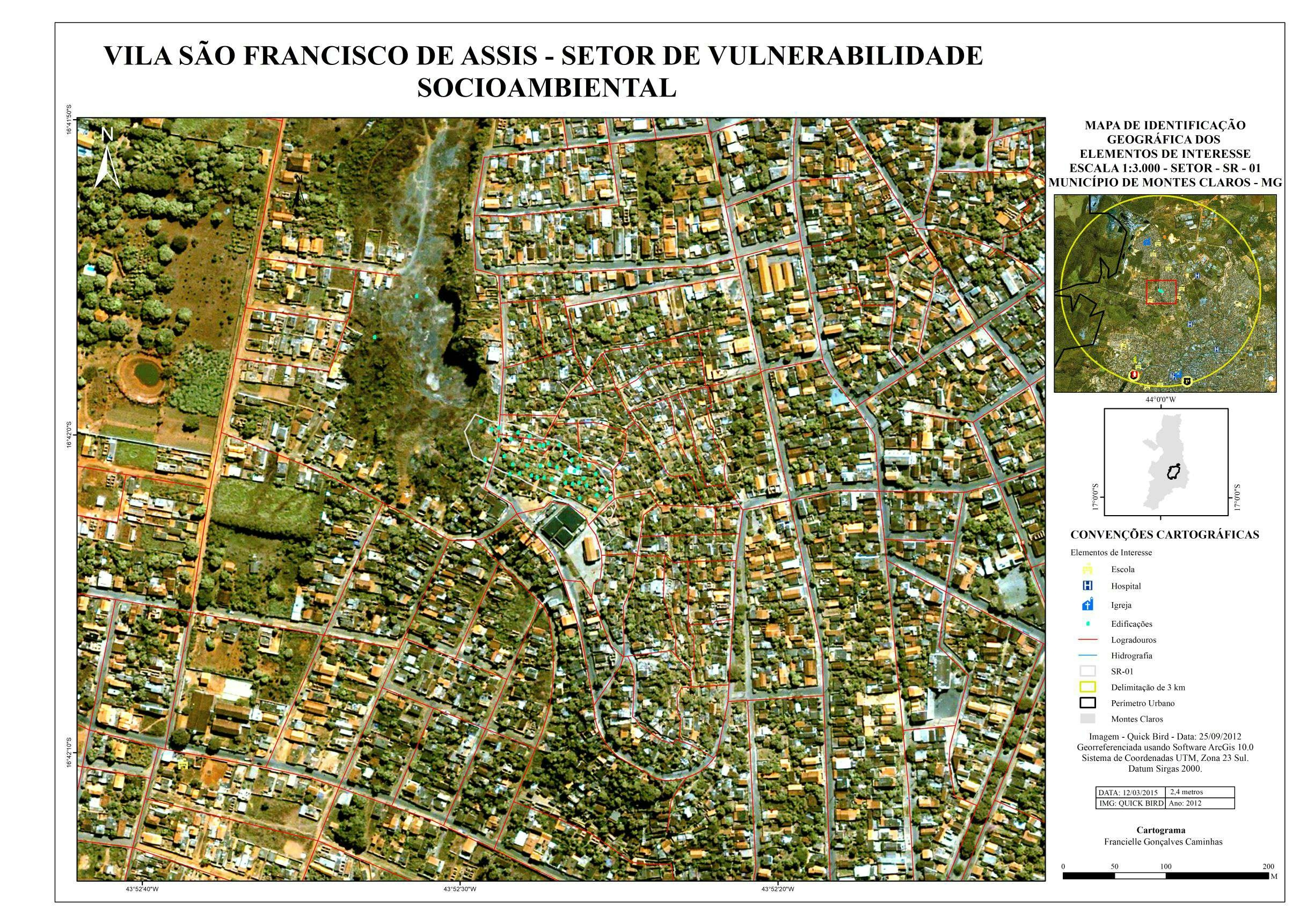
O mapa apresenta o Índice de Vulnerabilidade Socioambiental - IVSA, na Vila São Francisco de Assis, município de Montes Claros - MG.


Tools used

ArcGIS

Plug-ins used

ArcGIS

tags

ArcGISArcMap

More by Francielle Caminhas

Índice de Concentração de Rugosidade
9
PARÂMETROS DE EVOLUÇÃO DA PAISAGEM
14
IVN - Montes Claros, Minas Gerais (MG)
8
Parâmetros Físicos Montes Claros - MG
96
ÍNDICE DE EXPOSIÇÃO - MOVIMENTO DE MASSA
9
Distribuição das barraginhas UPGRH - SF8
85
Vias de acesso - Montes Claros - MG
83
IDENTIFICAÇÃO - SETOR VULNERABILIDADE
18
Vulnerabilidade Social - V. S Fran Assis
17

You might also like

Mapa Temático- diagnóstico médico de IST
Robert Caetano
Mapa Temático- diagnóstico médico de IST
Robert Caetano
64
How to Measure Land Use Mix via Entropy
Stewart Berry
How to Measure Land Use Mix via Entropy
Stewart Berry
362
Unemployment status of veterans in the labor workforce by US county 2009
Habeeb Abdulazeez
Unemployment status of veterans in the labor workforce by US...
Habeeb Abdulazeez
117
Image Intelligence for National Security
Alexandre Dargains Auricchio de Oliveira
Image Intelligence for National Security
Alexandre Dargains...
327
Forest lose Canopy, Nigeria
Comson Iyamisigh
Forest lose Canopy, Nigeria
Comson Iyamisigh
30
Multidimensional Poverty Index
PAULO CARVALHO
Multidimensional Poverty Index
PAULO CARVALHO
54
Colombia Water Transitions
Paola Prieto Botero
Colombia Water Transitions
Paola Prieto Botero
33
Banneker Park Dashboard
Matthew Tomitz
Banneker Park Dashboard
Matthew Tomitz
14
Cities with bike lanes in Brazil, states
Gustavo Soares Arrial
Cities with bike lanes in Brazil, states
Gustavo Soares Arrial
104
Mapa temporal das enchentes no RS (2/2)
Rodrigo Chemite Barbosa
Mapa temporal das enchentes no RS (2/2)
Rodrigo Chemite Barbosa
13
MAP OF ROADS
Joel NDAYISABA
MAP OF ROADS
Joel NDAYISABA
14
Tree location points on an avenue.
Thiago Andrade
Tree location points on an avenue.
Thiago Andrade
88

Join the community!

We're a place where geospatial professionals showcase their works and discover opportunities.

Sign Up for free