Sign up or log in to your Spatialnode account.

Takes less than a few seconds.

Land Cover Change Detection of Akure

Adeolu Oshadare
Adeolu Oshadare•

December 04, 2021

Land Cover Change Detection of Akure

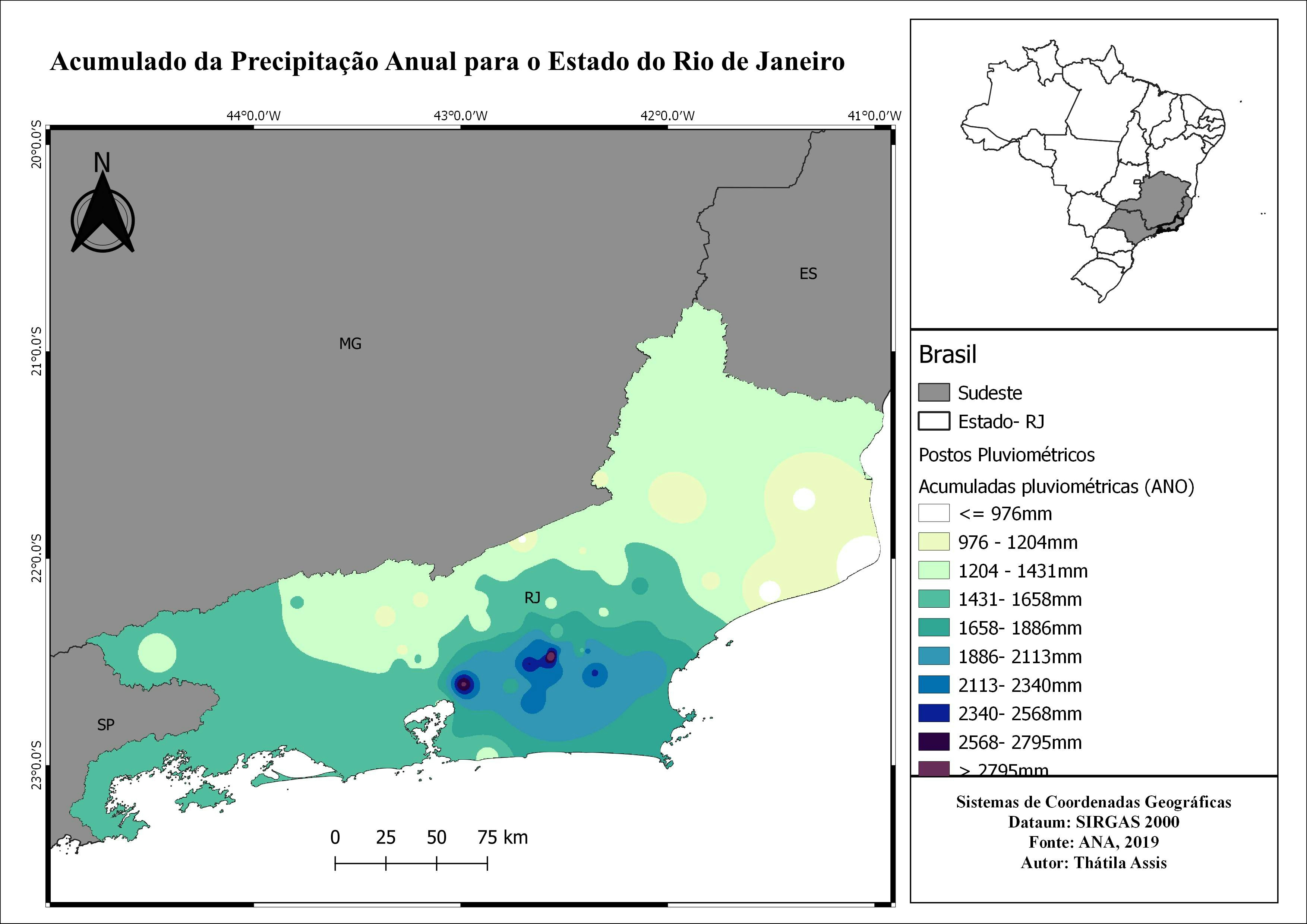
Showing the changes in the land cover of Akure


Tools used

ArcMapGoogle Earth Engine(GEE)

Plug-ins used

ArcMapGoogle Earth Engine(GEE)

tags

ArcGIS ProArcMapGoogle Earth Engine(GEE)

More by Adeolu Oshadare

Network Analysis
Network Analysis
527
Hotspot analysis
Hotspot analysis
556

You might also like

Watershed of the Paraíba do Meio River
Kauê Santos Lima
Watershed of the Paraíba do Meio River
Kauê Santos Lima
93
Location map
Daniel Rubens Santos Ribeiro
Location map
Daniel Rubens...
38
Non-Permanent Residents Growth, 2022-24
Francis Emmanuel Calingo
Non-Permanent Residents Growth, 2022-24
Francis Emmanuel CalingoPro
26
DEFENSIBILITY OF POLAND'S EASTERN FRONT
Spencer Scoresby
DEFENSIBILITY OF POLAND'S EASTERN FRONT
Spencer Scoresby
19
Let's have an AVOcuddle in Latin America
Ayeisha Sheldon
Let's have an AVOcuddle in Latin America
Ayeisha Sheldon
85
Boyaca Department limits in PostGIS QGIS
Paola Prieto Botero
Boyaca Department limits in PostGIS QGIS
Paola Prieto Botero
13
Land Use and Cover Baía da Guanabara, RJ
Genilson Ribeiro da Silva
Land Use and Cover Baía da Guanabara, RJ
Genilson Ribeiro...
60
Rio das Velhas
Matheus Amaral Prates
Rio das Velhas
Matheus Amaral Prates
8
Urban ravines in Puebla City
Miguel Santellan
Urban ravines in Puebla City
Miguel Santellan
34
Área de interesse econômico em Campinas
Eduardo Nardez
Área de interesse econômico em Campinas
Eduardo Nardez
7
YellowStone Lakes - A Story Map
Emmanuel Jolaiya Ayodele
YellowStone Lakes - A Story Map
Emmanuel Jolaiya Ayodele
74
Mapa Temático - Assentamentos
Gabriel Henrique Braga Matos
Mapa Temático - Assentamentos
Gabriel Henrique...
37

Join the community!

We're a place where geospatial professionals showcase their works and discover opportunities.

Sign Up for free