Master Thesis (Awarded by UNIGIS International)
A GIS APPROACH TO SUSTAINABLE LIVESTOCK PLANNING FROM CARBON DYNAMICS ANALYSIS - A case study of a cattle ranch in Serra da Mantiqueira (Brazil)
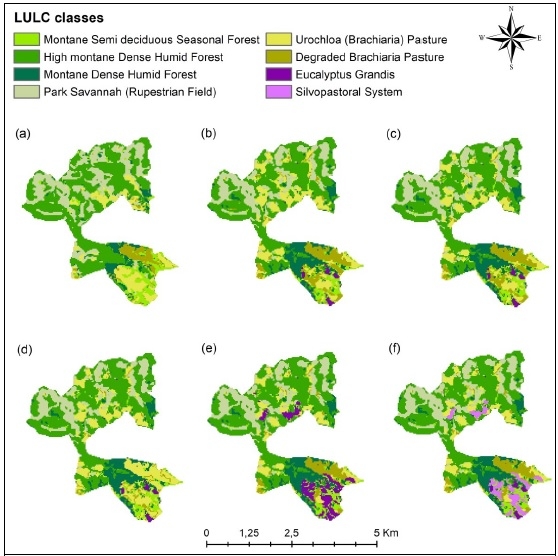
The assessment of carbon dynamics as indicator of climate-regulation ecosystem services (ES) through the modeling of different scenarios on land use and land cover (LULC) changes is widely used in environmental conservation studies to support the decision-making process regarding public policies. However, studies at local scales that address the subject under the farm property perspective, through impact and cost-benefit analyses of simulated sustainable farming scenarios on the provision of ecosystem services, are rare or nonexistent. In this paper, we performed the quantification, valuation and mapping of carbon capture and storage of past (2007-2017) and future LULC (2027) sustainable scenarios in a cattle ranch of Serra da Mantiqueira to understand how different LULC change scenarios may affect the provision of ES and contribute to economic opportunities to the farming sector. Under a GIS-approach, we used remote sensing techniques to LULC mapping, Integrated Valuation of Ecosystem Services and Tradeoffs (InVEST) model for scenario building, carbon assessment and valuation, as well as Sis family software modeling for forest management production. All the sustainable scenarios contributed to the increase of carbon capture and storage in the study area, in addition to showing profitable economic opportunities arising from their implementation. The introduction of eucalyptus trees in livestock and agricultural production systems is an interesting alternative for diversification and income increase, contributing to the balance of greenhouse gases (GHG) from livestock activity and adding value to production. These results are useful to support the development and planning for both environmental conservation policies and sustainable farming production.