
Interactive Map of Fish Farms in Kafr El Sheikh: A Comprehensive Analysis of Productivity and Opportunities
Introduction:
Kafr El Sheikh is one of the most important governorates in Egypt in the field of fish farming, as it contributes significantly to meeting the local market's needs for fish. This interactive map aims to provide a comprehensive analysis of the productivity and opportunities in the field of fish farming in Kafr El Sheikh, by collecting data from reliable sources and presenting it in an interactive and easy-to-use format.
Data Used:
Central Agency for Public Mobilization and Statistics (CAPMAS): Statistics were obtained on the number of fish farms, their fish production, the types of fish raised, and the number of workers in this field.
Other Sources: Additional information was collected from government websites
Outputs:
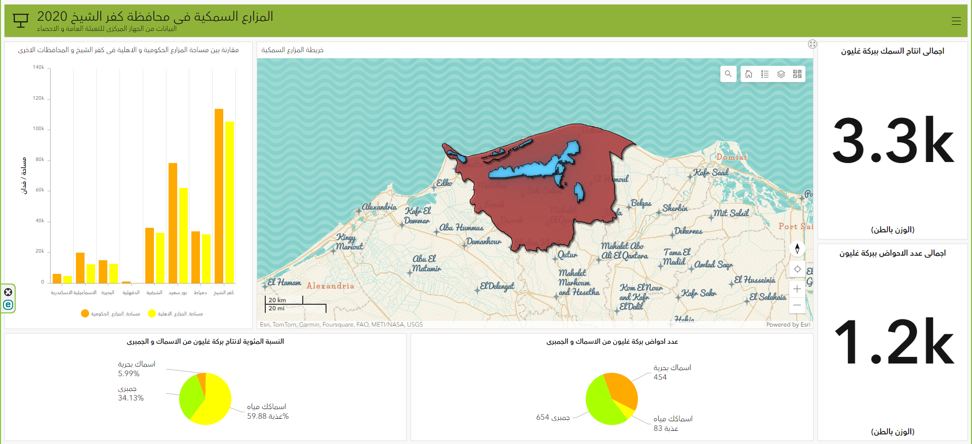
Map: The map shows the locations of fish farms in Kafr El Sheikh Identifying Opportunities: Investment opportunities in fish farming in Kafr El Sheikh were identified, with a focus on fish species with high market demand.
Dashboard: "The new dashboard about fish farms in Kafr El-Sheikh in 2020 is part of the web applications in my graduation project for the Geomatics Department at Helwan University in 2024."
I retrieved the data from CAPMAS and placed it in the attribute table, then I uploaded it to the ArcGIS Online
Challenges Faced:
Lack of Available Information: I faced difficulty in obtaining detailed information about all fish farms in Kafr El Sheikh. Inaccuracy of Some Data: Some of the available data was inaccurate or outdated.
Data Analysis Difficulty: I faced difficulty in analyzing the collected data due to its diversity and complexity.
Results:
Despite the challenges I faced, I was able to create a comprehensive interactive map of fish farms in Kafr El Sheikh. This map is a valuable tool for investors and decision-makers in the field of fish farming, as it provides them with detailed information about this sector and helps them identify viable investment opportunities.
Notes:
This map can be used as a model for similar projects in other Egyptian governorates.
This map can be developed in the future to add more information and features.


.jpg&w=3840&q=100)


.svg "Keran Nkongolo")


.jpg&w=3840&q=100)


1_1537132.png&w=3840&q=100)
