Sign up or log in to your Spatialnode account.

Takes less than a few seconds.

Mapa de Uso e Ocupação da Terra

Sidney dos Santos
Sidney dos Santos•

March 06, 2022

Mapa de Uso e Ocupação da Terra

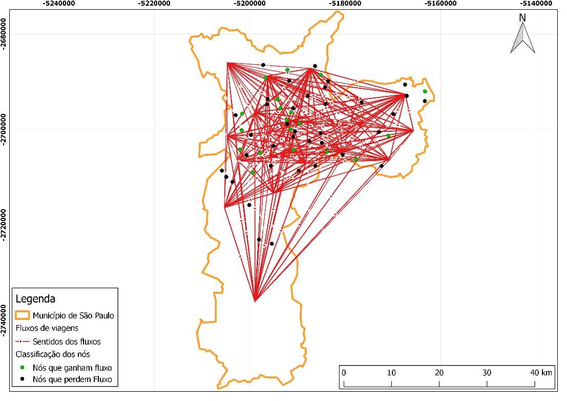
Mapa de Uso e Ocupação da Terra do município de São Paulo, elaborado em razão de pesquisa referente a localização dos modais de transportes da cidade.


Tools used

QGIS

Plug-ins used

Openlayers

tags

classificação supervisionadaLandsat 8uso e ocupação

More by Sidney dos Santos

Uso e Ocupação da Terra
57
Concentração de Cádmio
15
Composição Landsat 8
96
Fluxo de Viagens por bicicletas
40
Densidade Demográfica
5
CHIRPS Brasil
CHIRPS Brasil
116
Área de Proteção Permanente
9
Grau de severidade de queimadas
104
Mapa Hipsométrico
Mapa Hipsométrico
24
Mapa de Aspecto do Estado de São Paulo
106
Viagens por Bicicleta
6
Mapa de Declividade
Mapa de Declividade
147

You might also like

Estimating Canopy Height from LiDAR
Joe Pitti
Estimating Canopy Height from LiDAR
Joe Pitti
10
Satellite Imagery
Bertrand Lobo
Satellite Imagery
Bertrand Lobo
25
Hillshade gradient
Jardel Estevam Barbosa dos Santos
Hillshade gradient
Jardel Estevam...
49
Surface Ozone Over the James River
Ria Rathod
Surface Ozone Over the James River
Ria Rathod
16
Distribution Transformer Status Tracker
Oluwadara Tobi Oladele
Distribution Transformer Status Tracker
Oluwadara Tobi Oladele
48
MAPA DE USO DO SOLO E COBERTURA VEGETAL
Gustavo da Silva Francisco
MAPA DE USO DO SOLO E COBERTURA VEGETAL
Gustavo da...
12
UNDP Ukraine - Transition of Coal Cities
Emmanuel Oyerinde
UNDP Ukraine - Transition of Coal Cities
Emmanuel Oyerinde
4
Displacements Analysis to test centers
Alexandre Dargains Auricchio de Oliveira
Displacements Analysis to test centers
Alexandre Dargains...
309
Populated Places on Earth 🌍
Alexa Cristina
Populated Places on Earth 🌍
Alexa Cristina
82
IGR at the state level in Nigeria (2020)
Bamidele Daniel Ohinoyi
IGR at the state level in Nigeria (2020)
Bamidele Daniel Ohinoyi
58
LAND COVER CHANGES IN IFE CENTRAL LGA
Damilola Fadipe
LAND COVER CHANGES IN IFE CENTRAL LGA
Damilola Fadipe
17
Spotted Lanternfly Spread in the US
Emma Stern
Spotted Lanternfly Spread in the US
Emma Stern
16

Join the community!

We're a place where geospatial professionals showcase their works and discover opportunities.

Sign Up for free