Sign up or log in to your Spatialnode account.

Takes less than a few seconds.

Raleigh Park Access

Ryan Cooper
Ryan Cooper•

December 01, 2021

Raleigh Park Access

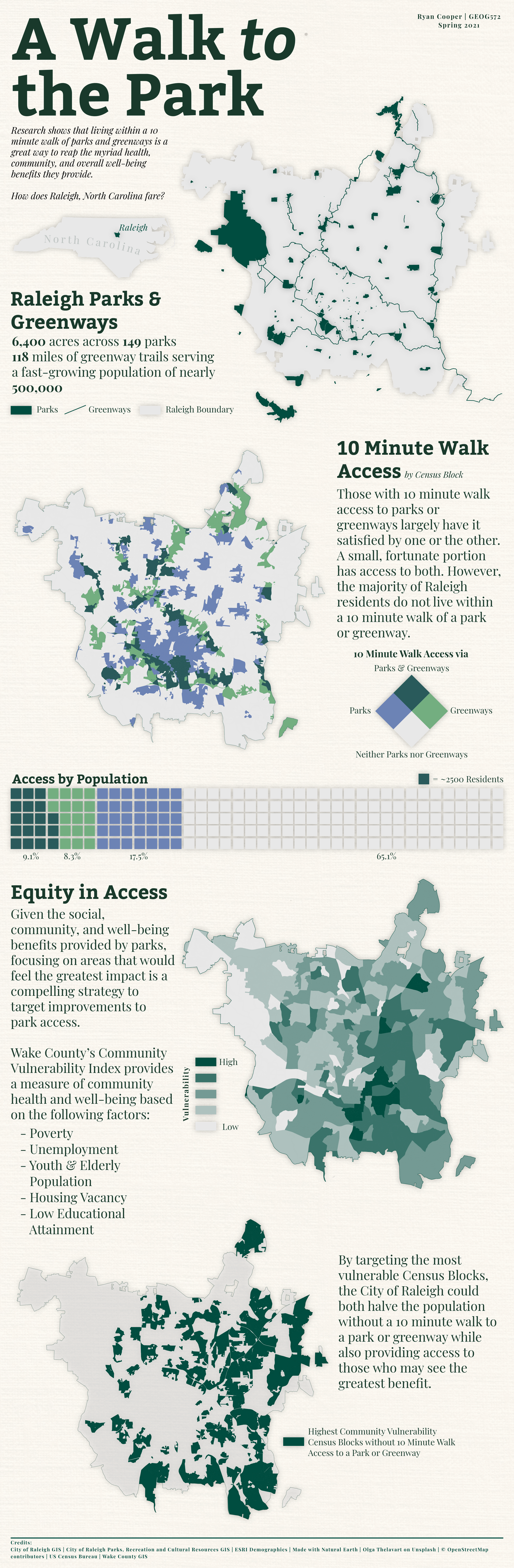
This longform infographic examines 10 minute walk access to parks in Raleigh, NC and proposes a social equity approach to prioritizing access improvements.

Demo

Tools used

Adobe IllustratorArcGIS ProValhalla

Plug-ins used

Matplotlib

tags

CartographyData VisualizationInfographic

More by Ryan Cooper

Raleigh Center Analysis
527
Yellow-Bellied Sapsucker Seasonal Range
378
Busiest Container Ports, 2004-2019
576
PRCR Bird's Eye
PRCR Bird's Eye
311
Old North State Bike Race Map
326
Citrix Cycle Raleigh Bike Share Rides
341

You might also like

Mapa Analítico Hipsométrico
Gabriel Henrique Braga Matos
Mapa Analítico Hipsométrico
Gabriel Henrique...
40
Projeto de Iniciação Cientifica
Polliana Odeth de Melo Machado
Projeto de Iniciação Cientifica
Polliana Odeth...
28
MAPA INDICAÇÃO DE ARVORE PARA SUPRESSÃO
Edvaldo Alves Neto
MAPA INDICAÇÃO DE ARVORE PARA SUPRESSÃO
Edvaldo Alves Neto
150
Série de Mapas da " Estrada Catimbau"
Daniel Conceição do Nascimento
Série de Mapas da " Estrada Catimbau"
Daniel Conceição...
12
Carbonate Formations of Attica (greek)
Efstathios Lymperis
Carbonate Formations of Attica (greek)
Efstathios Lymperis
184
Los Alcornocales Natural Park
Marcelo Aguilera
Los Alcornocales Natural Park
Marcelo Aguilera
552
Mapa da localização de Sete Lagoas - MG
Raiane Mechetti Ferreira
Mapa da localização de Sete Lagoas - MG
Raiane Mechetti Ferreira
20
NDVI de Cametá, PA
Giovanni Augusto Valente da Silva
NDVI de Cametá, PA
Giovanni Augusto...
22
Land Cover in Boston Subwatersheds
Dylan Kelly
Land Cover in Boston Subwatersheds
Dylan Kelly
7
MN River Flood MitigationforSt.Peter,MN
Dane Lewandowski
MN River Flood MitigationforSt.Peter,MN
Dane Lewandowski
11
GW & Jeff. Forest Planning Assessment
Bryan Smalley
GW & Jeff. Forest Planning Assessment
Bryan Smalley
3
Transit Accessibility Catchment Area Lab
Henry Paddock
Transit Accessibility Catchment Area Lab
Henry Paddock
15

Join the community!

We're a place where geospatial professionals showcase their works and discover opportunities.

Sign Up for free