Sign up or log in to your Spatialnode account.

Takes less than a few seconds.

Tectonic & Lithological Map - CTFB & IBR

Niroj Shrestha
Niroj Shrestha•

July 10, 2023

Tectonic & Lithological Map - CTFB & IBR

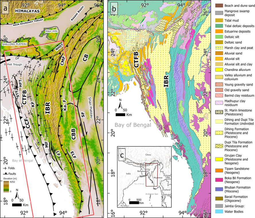
Tectonic and Lithological map of Thrust and Fold Belt, Eastern Bengal Basin 


Tools used

ArcGIS Pro

Plug-ins used

Spatial analyst

tags

GeologyGISLithology

More by Niroj Shrestha

Absolute Pop Change CSA
18
Fire Station Response Time
28
Site Selection for a New Fire Station
17
Distribution of Churches in U.S.
18

You might also like

Urban Expansion in DC (1990-2015)
Simone Chapman
Urban Expansion in DC (1990-2015)
Simone Chapman
130
Washington Yarn Map
Cari Lynn Squibb
Washington Yarn Map
Cari Lynn Squibb
40
Rio Pandeiros watershed
Rik Ferreira Alves
Rio Pandeiros watershed
Rik Ferreira Alves
6
Focos de queimada Pantanal
José Geraldo Ribeiro Junior
Focos de queimada Pantanal
José Geraldo...
3
Japan's Megaquake: Liquefaction Threat
Solena Kronstedt
Japan's Megaquake: Liquefaction Threat
Solena Kronstedt
20
Modelo Digital de Elevação
Letícia Vieira C.
Modelo Digital de Elevação
Letícia Vieira C.
16
Helping non-GIS people be GIS people
Sherri Michl
Helping non-GIS people be GIS people
Sherri Michl
102
Pemba Ward wise population distributon
Hashimu Misanya
Pemba Ward wise population distributon
Hashimu Misanya
35
2a. Global Particulate Matter
carson allen
2a. Global Particulate Matter
carson allen
4
Inundação do Rio Grande do Sul em 2024
Matheus Maciel
Inundação do Rio Grande do Sul em 2024
Matheus Maciel
14
Land Use Analyzer
Alexandros Voukenas
Land Use Analyzer
Alexandros Voukenas
39
Potential Ornithology Society of Surrey
Rodney Wong
Potential Ornithology Society of Surrey
Rodney Wong
3

Join the community!

We're a place where geospatial professionals showcase their works and discover opportunities.

Sign Up for free