Sign up or log in to your Spatialnode account.

Takes less than a few seconds.

Topographical Map of Lagos Mainland

Emeka Ude
Emeka Ude•

July 10, 2023

Topographical Map of Lagos Mainland

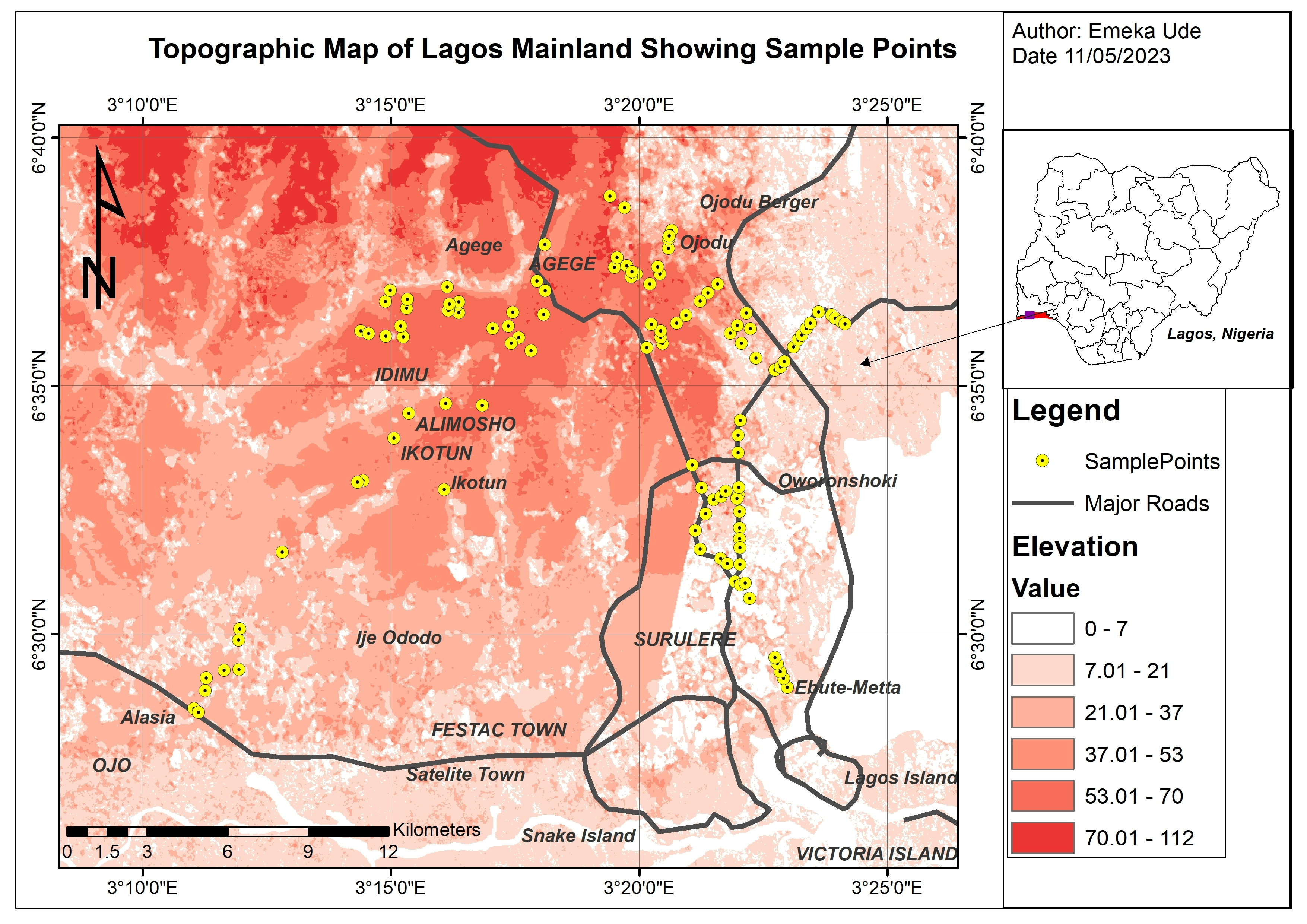
A study that shows spatial distribution of sample points with the base map of topographical map.


Tools used

ArcGISArcMapGoogle Earth ProMicrosoft Excel

Plug-ins used

ArcMap

tags

Elevationlagos, Nigeriatopographic map

More by Emeka Ude

Traverses of Geophysical Survey, Unilag
10
Study Area Map of Nsukka Metropolis
98
Elevation Map of Abakaliki Nigeria
50
EzeAni Groundwater Quality
46
Topographic Map of Obukpa
131
Temperature Along Nigerian Coastal Line
34
Liberty Ibadan Street Map
35
Study Area in Southwest Nigeria
24
Hourly Ozone Distribution in California
66
Delineations of Asa River Watershed
97
Geochemical Map in Southwest, Nigeria
21
Osun State elections 2022
95

You might also like

The Citadel of Farah, Afghanistan
Sebastian Silva
The Citadel of Farah, Afghanistan
Sebastian Silva
189
Carbonate Morphology
Adi Neuman
Carbonate Morphology
Adi Neuman
11
Isola d'Elba - Shaded Relief
Federica Gaspari
Isola d'Elba - Shaded Relief
Federica Gaspari
108
Uso do solo temporal 1990 a 2020
Márcio Marques de Alencar Arraes
Uso do solo temporal 1990 a 2020
Márcio Marques...
45
Wyoming Active Oil and Gas Wells
Keran Nkongolo
Wyoming Active Oil and Gas Wells
Keran NkongoloPro
31
Shropshire National Character Areas
Millie Brand
Shropshire National Character Areas
Millie Brand
12
Gray Wolf Habitat Suitability Index
Colin Young
Gray Wolf Habitat Suitability Index
Colin YoungPro
32
Bacia Hidrográfica do Açude Baião
Daniel Conceição do Nascimento
Bacia Hidrográfica do Açude Baião
Daniel Conceição...
29
Soil Texture map
Ologun Emmanuel Ayowole
Soil Texture map
Ologun Emmanuel Ayowole
29
Illinois River Watershed Land Cover
Isaac Ajayi
Illinois River Watershed Land Cover
Isaac AjayiPro
27
Uso e cobertura da terra
Vanessa Cristiane Santos
Uso e cobertura da terra
Vanessa Cristiane Santos
14
Iceland, the Faroe and Shetland Islands
Kareen Bröker
Iceland, the Faroe and Shetland Islands
Kareen Bröker
72

Join the community!

We're a place where geospatial professionals showcase their works and discover opportunities.

Sign Up for free