Sign up or log in to your Spatialnode account.

Takes less than a few seconds.

Algae bloom

Kolawole Arowoogun
Kolawole Arowoogun•

December 04, 2021

Algae bloom

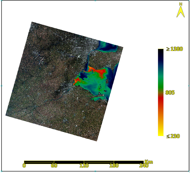
HAB distribution in Lake Erie generated from 2017 Landsat 8 imagery


Tools used

ENVI

Plug-ins used

Esri

tags

Esri

More by Kolawole Arowoogun

Suitability analysis
406
Hotspot
Hotspot
614
Outlier analysis
Outlier analysis
625
NDVI Map of Fulton County
75
Mapping 2021 Dixie wildfire.
297
Supervised Classification Map of Hall County, Georgia
241
Mount Helen Eruption Map
263
Map of Tract and census population data
37
Supervised classification image of Hall County, Georgia
254
Outlier analysis
Outlier analysis
603
Visualizing 2016 US Election
252

You might also like

Land Cover Mapping with Python
Bertrand Lobo
Land Cover Mapping with Python
Bertrand Lobo
116
KERIO VALLEY AGROECOLOGICAL ZONES, Kenya
John Wahome Gathoni
KERIO VALLEY AGROECOLOGICAL ZONES, Kenya
John Wahome Gathoni
94
Jbel Moussa Landscape
Hamza Bouarakia
Jbel Moussa Landscape
Hamza Bouarakia
195
Troutdale Wells
Harrison Howe
Troutdale Wells
Harrison Howe
12
Population Heat Map - Arkansas
Martin Nuñez Igarzabal
Population Heat Map - Arkansas
Martin Nuñez Igarzabal
58
Heat Map produced by Python ETL Script
Alexandre Dargains Auricchio de Oliveira
Heat Map produced by Python ETL Script
Alexandre Dargains...
419
Portland USA Waterlines
Alysha Anderson
Portland USA Waterlines
Alysha Anderson
4
Atlanta Greenspace Spatial Distribution
Maggie Zou
Atlanta Greenspace Spatial Distribution
Maggie Zou
50
California Water Appropriation
Caitlin McWilliams
California Water Appropriation
Caitlin McWilliams
8
Mancha de Inundação de Manacapuru - Am
Ana Carolina Gomes Correa
Mancha de Inundação de Manacapuru - Am
Ana Carolina...
45
| AEROLEVANTAMENTO - REURB |
Diogo Henrique Rodrigues Junior
| AEROLEVANTAMENTO - REURB |
Diogo Henrique...
56
Land Cover Map for Machinga, Malawi
Olive Caroline Mandalasi
Land Cover Map for Machinga, Malawi
Olive Caroline Mandalasi
66

Join the community!

We're a place where geospatial professionals showcase their works and discover opportunities.

Sign Up for free