Sign up or log in to your Spatialnode account.

Takes less than a few seconds.

Suitability analysis

Kolawole Arowoogun
Kolawole Arowoogun•

November 22, 2021

Suitability analysis

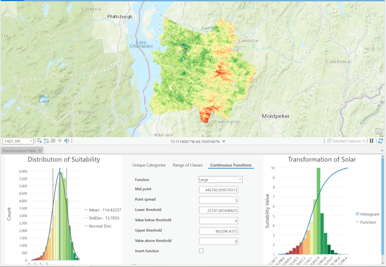
Suitability analysis model for determining the locations of a proposed low carbon footprint headquarter in Vermont.


Tools used

ArcGIS Pro

Plug-ins used

ArcGIS Pro

tags

ArcGIS Pro

More by Kolawole Arowoogun

Map of Tract and census population data
35
Outlier analysis
Outlier analysis
618
Hotspot
Hotspot
610
NDVI Map of Fulton County
73
Supervised Classification Map of Hall County, Georgia
240
Mount Helen Eruption Map
254
Supervised classification image of Hall County, Georgia
254
Visualizing 2016 US Election
248
Mapping 2021 Dixie wildfire.
292
Algae bloom
Algae bloom
628
Outlier analysis
Outlier analysis
601

You might also like

Population  (Rwanda- Northern Province)
Jose Rubio-Valverde
Population (Rwanda- Northern Province)
Jose Rubio-Valverde
135
Lake Nakuru Flood Simulation
PETER NDIRITU THUKU
Lake Nakuru Flood Simulation
PETER NDIRITU THUKU
85
Cartographer
Oladeji Muhammed
Cartographer
Oladeji Muhammed
96
Mapa - Produção Ágricola no Brasil 2016
Felipe Duarte de Castro
Mapa - Produção Ágricola no Brasil 2016
Felipe Duarte...
65
Micro bacia do rio Merim - Alagoas
Priscila Andreza dos Santos Buarque
Micro bacia do rio Merim - Alagoas
Priscila Andreza...
11
GDAL: JPEGs Image Preview and Tile Index
Paola Prieto Botero
GDAL: JPEGs Image Preview and Tile Index
Paola Prieto Botero
24
Uso do solo Regional Centro Sul / Bhte
Emerson José Gonçalves
Uso do solo Regional Centro Sul / Bhte
Emerson José Gonçalves
462
Virginia Agricultural Forest Districts
Keran Nkongolo
Virginia Agricultural Forest Districts
Keran NkongoloPro
11
Precambrian in africa.
Olumoyegun promise Ayo
Precambrian in africa.
Olumoyegun promise Ayo
583
New Cairo Neighborhood Mapping Project
Shaukat Abdelfatah Abdelmaqsoud Mohammed
New Cairo Neighborhood Mapping Project
Shaukat Abdelfatah...
9
Nigerian State Map by Geozone
Samuel Eyo
Nigerian State Map by Geozone
Samuel Eyo
18
BH do rio Andirá, uso e cobertura
Andrei Tavares Fernandes
BH do rio Andirá, uso e cobertura
Andrei Tavares Fernandes
10

Join the community!

We're a place where geospatial professionals showcase their works and discover opportunities.

Sign Up for free