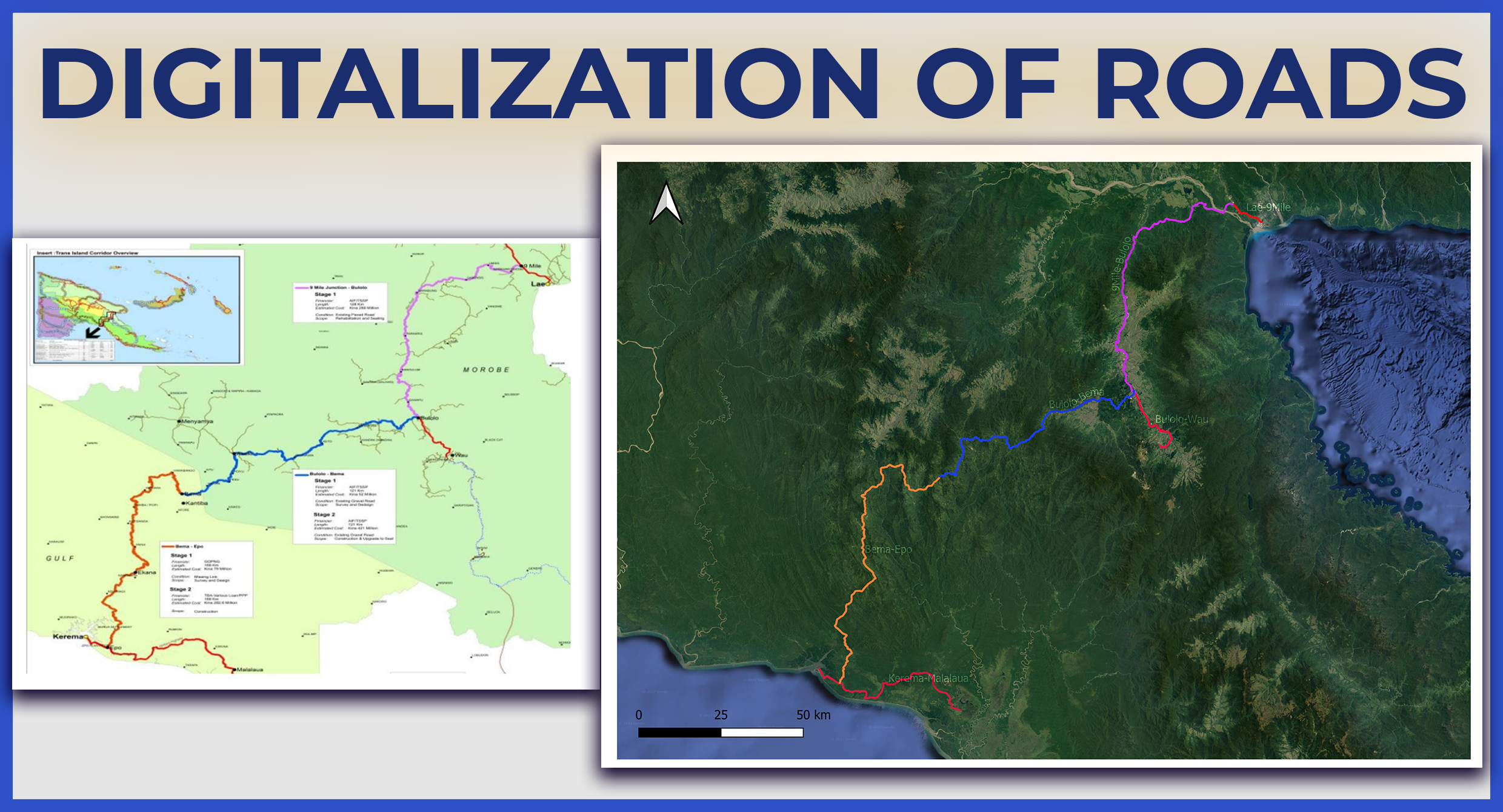
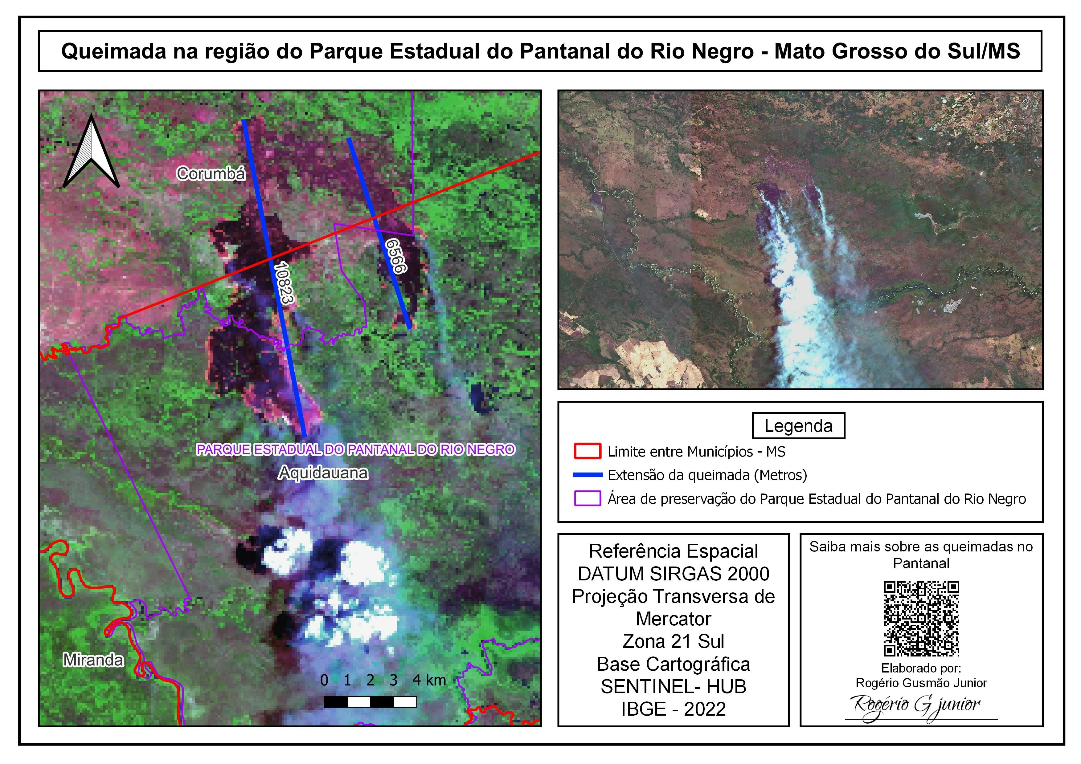
.png&w=3840&q=100)
Objective
The primary objective of this project is to assess the health and temporal dynamics of the mangrove forests within the Sundarbans region of Bangladesh. This is achieved by generating a long-term, monthly-averaged NDVI (Normalized Difference Vegetation Index) time series from 2016 to 2024. NDVI serves as a proxy for vegetation density and health, allowing for the monitoring of growth, stress, and potential changes in the mangrove ecosystem over time.
Data Acquisition
Mangrove Baseline Data: The project used the Global Mangrove Forests Distribution (2000) dataset from Landsat to establish the baseline extent of the mangroves.
Satellite Imagery for Time-Series: The Sentinel-2 MSI Harmonized image collection was used for the primary analysis due to its high spatial resolution (10m) and frequent revisit time.
Ancillary Data: The Google Cloud Score+ dataset was integrated to provide pixel-level quality assessment for robust cloud and shadow masking.
Data Processing
The project was executed in two distinct phases:
Phase 1: Defining the Region of Interest (ROI)
The baseline mangrove map for Bangladesh was clipped to a specific study area within the Sundarbans using a user-defined rectangle.
This raster data was then converted into a single, unified vector polygon using
reduceToVectorsandunion(). This step was crucial to create a precise boundary that encompasses only the mangrove forest area for accurate NDVI extraction.
Phase 2: Time-Series Analysis
Filtering: The Sentinel-2 collection was filtered by date (2016-2024) and the mangrove polygon geometry.
Cloud Masking: The Cloud Score+ dataset was linked to the imagery, and a function was applied to mask out pixels with a high probability of being clouds.
NDVI Calculation: The NDVI was computed for each cloud-masked image using the Red (B4) and Near-Infrared (B8) bands.
Temporal Aggregation: The processed images were grouped by year and month, and a monthly mean NDVI composite was generated for the entire mangrove polygon. This step reduces noise and data volume, creating a clean, consistent time series.
Data Analysis
The final output is an interactive line chart that plots the average NDVI value for the entire mangrove forest against time. This visualization allows for the analysis of:
Seasonal Patterns: Observing regular, intra-annual cycles of growth and senescence in the mangroves.
Long-Term Trends: Identifying gradual increases or decreases in overall forest health and density over the 8-year period.
Anomalies: Detecting sudden drops in NDVI that could indicate events like cyclones, drought, or illegal logging.
Potential Usage and Impact
Environmental Monitoring: Track the impact of climate change, sea-level rise, and extreme weather events on the world's largest mangrove forest.
Conservation Management: Provide data-driven insights for government and NGOs to evaluate the effectiveness of conservation policies and reforestation efforts.
Scientific Research: Serve as a baseline for studies on carbon sequestration, biodiversity, and coastal ecosystem services.
Disaster Assessment: Quickly assess damage to the mangrove belt after major cyclones, which act as a natural bio-shield for the coastline.GitHub Code Link: https://github.com/mohammadoney/NDVI-Time-Series-Analysis-2016-2024-/blob/main/Source%20Code
.png&w=3840&q=100)
.png&w=3840&q=100)