Sign up or log in to your Spatialnode account.

Takes less than a few seconds.

Unilorin Teak Plantation

Damilola Fadipe
Damilola Fadipe•

June 29, 2022

Unilorin Teak Plantation

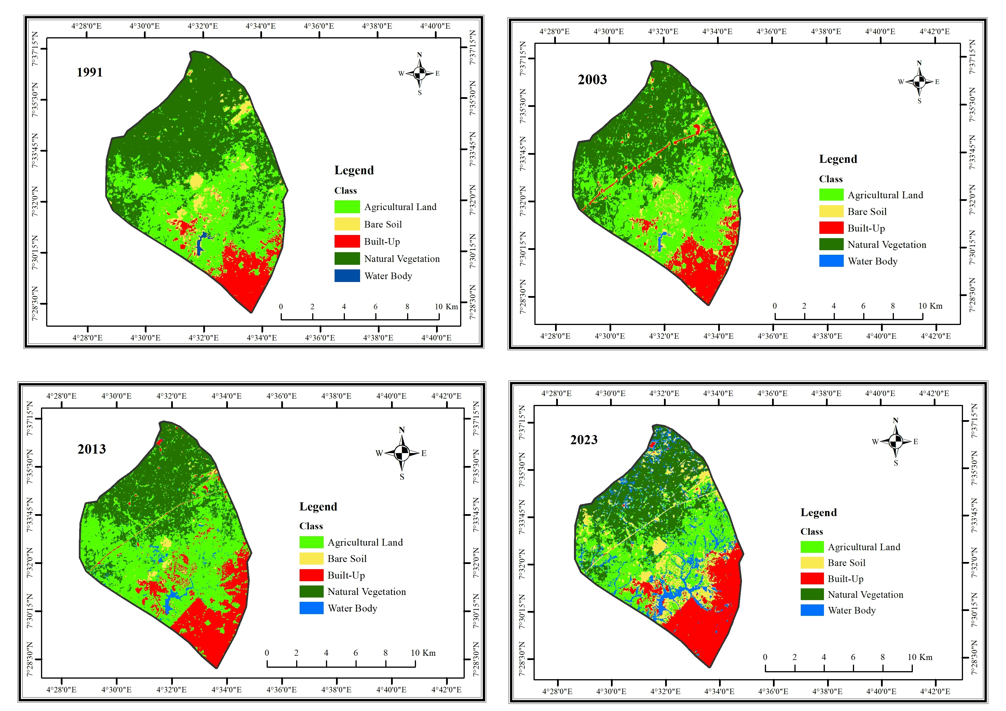
Map of University of Ilorin Teak plantation


Tools used

ArcMapQGIS

Plug-ins used

Esri

tags

parks

More by Damilola Fadipe

LAND COVER CHANGES IN IFE CENTRAL LGA
17
Lekki Conservation Center
98
FLOW MAP OF PEOPLE INTO NYANYA, FCT
37
Study Area Map
Study Area Map
28

You might also like

Cartographic basemap with hillshade
Adedoyin Ajeyomi
Cartographic basemap with hillshade
Adedoyin Ajeyomi
138
Município de Ourinhos-SP
Anderson Oliveira
Município de Ourinhos-SP
Anderson Oliveira
151
School Mapping and Micro-planning
Girma Kussa
School Mapping and Micro-planning
Girma Kussa
175
Land Cover in Boston Subwatersheds
Dylan Kelly
Land Cover in Boston Subwatersheds
Dylan Kelly
23
City of Redding
Harrison Hyatt
City of Redding
Harrison Hyatt
24
Biomas do Brasil
Ajumar Omar Alfaica
Biomas do Brasil
Ajumar Omar Alfaica
10
PRE-COLONIAL BOUNDARY MAP OF RWANDA
Joel NDAYISABA
PRE-COLONIAL BOUNDARY MAP OF RWANDA
Joel NDAYISABA
2.5K
Study Area Map of Nsukka Metropolis
Emeka Ude
Study Area Map of Nsukka Metropolis
Emeka Ude
114
Escolas Educacao Infantil Recife-Voronoi
Renata Maciel
Escolas Educacao Infantil Recife-Voronoi
Renata Maciel
8
Land Cover Maps
Ananda Rianti Dewi
Land Cover Maps
Ananda Rianti Dewi
15
Spatial Analysis - Drive time (QGIS Map)
Martin Nuñez Igarzabal
Spatial Analysis - Drive time (QGIS Map)
Martin Nuñez Igarzabal
21
Land Use Change SE Pennsylvania
Alexandria Hahn
Land Use Change SE Pennsylvania
Alexandria Hahn
22

Join the community!

We're a place where geospatial professionals showcase their works and discover opportunities.

Sign Up for free