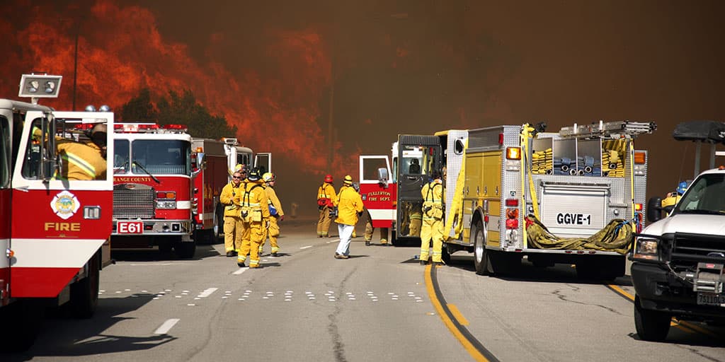
What is Disaster?
Disasters are catastrophic disruptions in a community or society's ability to function, resulting in significant losses in people, property, the economy, or the environment. Occurs when extensive losses exceed the capacity of the impacted community. (UNISDR)
An extreme event that significantly deviates from the norm within the earth's system (lithosphere, hydrosphere, biosphere, or atmosphere), causing human death or injury as well as damage to or loss of "goods" like infrastructure, communications, and the natural environment (Alexander, 1993).
A disaster happens when a sizable number of vulnerable people are exposed to risk, and their livelihood systems are severely damaged and disrupted, making a full recovery improbable without outside assistance. (Blaikie1994)
Is Disaster the same as a Hazard?
In disaster management, Disaster and hazard are similar terms, although they stand for various components of the broader framework.
A condition or event that could be dangerous or destructive and result in harm, damage, or the loss of life or property is referred to as a hazard. Hazards can be artificial or natural, such as chemical spills, industrial accidents, or terrorist attacks. Natural hazards include earthquakes, floods, storms, and wildfires. In terms of size, frequency, and severity, hazards might differ. They can injure or damage vulnerable populations, infrastructure, or ecosystems, which is how they can be identified.
On the other side, a disaster is when a risk really materialises or occurs. The damage, devastation, disruption, or loss of life and property caused by the event or series of events exceeds the ability of the afflicted community or society to cope with the situation using its resources. Hazards have real-world repercussions where the impact and effects are visible. Disasters can affect the afflicted areas in both the short- and long-term, with effects on the social, economic, and environmental conditions.
Data showing worldwide Disaster occurrences
The world has experienced rising economic losses as a result of disasters.
• From 2010 to 2012, economic losses exceeded $100 billion (UNISDR, 2013).
• Damages totalling $2.3 trillion over the past three decades (World Bank, 2010)
• Between 1982 and 2013, 2.6 billion US dollars in total losses were incurred, and 2.4 million global deaths were reported by EM-DAT (national databases excluded).
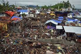
According to the Emergency Event Database EM-DAT, 387 natural disasters and hazards globally in 2022 claimed 30,704 lives and impacted 185 million people. The amount of economic damages was about US$223.8 billion.
In Europe, heat waves contributed to almost 16,000 extra deaths, but 88.9 million people in Africa were harmed by droughts (the main reason I'm currently researching drought).
The overall number of catastrophic occurrences in 2022 (387) is slightly higher than the 370 average from 2002 to 2021. Each sort of calamity occurred about as frequently as it did over the previous 20 years on average.
The overall death toll in 2022 was 30,704, which was three times more than in 2021 but lower than the average of 60,955 deaths between 2002 and 2021 (the latter being influenced by a few mega-disasters, including the 2010 Haiti earthquake, which resulted in 222,570 dead). The 2022 death toll is nearly twice as high as the median death toll between 2002 and 2021, which was 16,011.
After the European heat waves, the drought-induced famine in Uganda claimed 2,465 lives in 2022, making it the second-deadliest catastrophic event. Additionally, 88.9 million people were affected by droughts in six African nations in 2022 (the Democratic Republic of the Congo, Ethiopia, Nigeria, Sudan, Niger, and Burkina Faso). Other notable drought episodes included those in Brazil ($4 B), the USA ($22 B), and China (6.1 M people impacted, $7.6 B in damage) (Reliefweb).
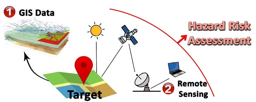
What is GIS?
Geographic Information System is referred to as GIS. It is a technology that makes it possible to gather, examine, comprehend, display, and manage geographic data.
GIS combines attribute data—descriptive data about the spatial features—with spatial data—information that includes a geographic component—to produce a thorough knowledge of the relationships and patterns in the data. It offers a framework for gathering, organising, manipulating, and displaying geographic data, empowering users to take well-informed decisions and resolve challenging issues involving geographic phenomena.
With the use of specialized software, hardware, and data, GIS technology can carry out a number of activities, such as:
• Data Capture
• Data Management
• Data Analysis
• Data Visualization
• Modelling, simulation,
• Spatial query and retrieval.
• Decision Support
GIS as a Decision-making tool for Disaster management
Regarding phenomena like disasters, GIS is more than simply a technology; it is a tool that aids in decision-making for the analyst and the relevant authorities. Through insights like this, decisions that genuinely save lives can be made. GIS can help you identify what is hidden and the places at risk of Disaster occurring repeatedly. It also helps you highlight the regions extremely prone to a specific form of Disaster.
The ultimate objective of GIS use in disaster management is to facilitate and improve sound decision-making that saves lives and properties.
Due to its ability to provide crucial geographical information and analytical tools, GIS functions as a strong decision support system (DSS) in the management of catastrophes. The following describes how GIS works as a DSS in disaster management:
1. Integrating and Visualizing Data
Satellite imagery, aerial photos, sensor data, infrastructure maps, population data, and danger information are just a few of the data sources that GIS incorporates. It uses maps, charts, and graphs to show this data visually, making it easier to comprehend the crisis. Decision-makers can immediately understand the spatial context, spot trends, and evaluate the gravity and scope of the crisis.
2. Spatial Analysis and Modelling:
GIS supports sophisticated spatial analysis and modelling techniques, including overlay analysis, proximity analysis, network analysis, and terrain analysis. These abilities support the identification of sensitive locations, the estimation of potential impact zones, the simulation of scenarios, and the prognosis of hazard propagation. Alternative courses of action can be assessed for potential implications, and decision-makers can choose the best response and recovery tactics.
3. Risk Assessment and Planning:
GIS facilitates risk assessment and management by fusing information on vulnerability and exposure with hazard data. GIS uses geographical analysis to detect high-risk locations, vulnerable populations, crucial infrastructure, and evacuation routes. Decision-makers can use this data to efficiently prioritise mitigation initiatives, prepare emergency responses, and allocate resources.
4. Real-Time Monitoring and Early Warning:
GIS combines real-time information from various sources, including weather stations, sensors, and social media feeds. GIS-based DSS can send timely warnings, activate automated response mechanisms, and update decision-makers on the situation by continuously monitoring it. This makes it possible to make prompt decisions and respond to emergencies quickly, potentially saving lives and limiting damage.
5. Resource Allocation and Logistics:
By taking into account variables like proximity, capacity, demand, and accessibility, GIS aids in resource allocation during disasters. It enables decision-makers to choose appropriate hospital sites, distribution hubs, and emergency shelters. Routing and logistics systems built on GIS make it easier to move supplies, manpower, and emergency services to affected areas.
6. Coordination and communication:
GIS acts as a focal point for parties participating in disaster management to share spatial data, situational updates, and action plans. Decision-makers may work together, plan out responses, and instantly exchange vital data. Access to information on disasters is made possible via interactive web-based maps and mobile applications, improving communication and public awareness.
7. Post-Disaster Assessment and Recovery:
GIS assists with post-disaster assessments by gathering, organizing, and analyzing information on infrastructure requirements, population relocation, and damage assessments. On the basis of precise spatial information, decision-makers can allocate resources, prioritize recovery efforts, and plan reconstruction projects. Monitoring and evaluating the effectiveness of the recovery process is made easier by GIS-based DSS.
In conclusion, GIS provides data integration, spatial analysis, visualization, and real-time monitoring capabilities, serving as a powerful decision support system in disaster management. It improves total disaster response and recovery efforts through improved decision-making, coordination, and resource allocation.
References
Malczewski, J. (2004). GIS-based multicriteria decision analysis: a survey of the literature. International Journal of Geographical Information Science, 20(7), 703-726.
Cheng, C., & Xu, X. (2017). GIS-based spatial decision support systems: A review. ISPRS International Journal of Geo-Information, 6(8), 241.
Tomlin, C. D. (Ed.). (2018). Geographic Information Systems and Cartographic Modeling. Routledge.
Goodchild, M. F. (2010). Twenty years of progress: GIScience in 2010. Journal of Spatial Information Science, 1(1), 3-20.
Cova, T. J. (2003). GIS in emergency management. In Encyclopedia of information systems (Vol. 2, pp. 237-255). Elsevier.
Clarke, K. C., & Hopp, C. R. (2015). GIScience and decision making. In The SAGE handbook of GIS and society (pp. 240-257). SAGE Publications.
Openshaw, S., & Abrahart, R. (2000). Geographical information systems: Principles, techniques, management, and applications. Wiley.