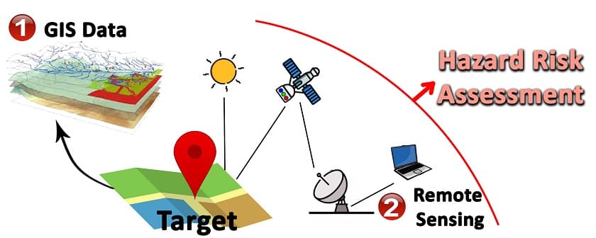
Disaster management is always changing to reduce the impact of natural and human-caused disasters on the population and environment. Remote sensing and GIS have transformed how we monitor, map, and assess disaster damage over time.
1. Monitoring:
Satellites and aircraft provide a bird's-eye view of disaster-prone areas. Hurricanes, floods, and wildfires can be detected early by monitoring these locations. Remote sensing gives decision-makers a complete picture of changing environmental circumstances, allowing them to plan and implement catastrophe preparedness actions.
Early Detection and Warning Systems: Satellite imaging, aerial surveys, and other remote sensing platforms are used to continuously monitor disaster-prone areas. These measurements can indicate possible disasters by tracking environmental factors like temperature, precipitation, sea surface temperature, and vegetation indices. By collecting and interpreting these data, early warning systems can advise authorities and communities about potential threats, allowing prompt evacuation and preparedness.
Remote sensing and GIS provide real-time situational awareness during disasters. Satellite and aerial photographs are quickly collected and processed to provide maps and geographical information on affected areas. These maps can track the crisis, highlight high-risk locations, and aid resource allocation and emergency response coordination. Real-time monitoring improves disaster assessment and response.
Environmental Monitoring: Remote sensing and GIS extend disaster monitoring. It allows post-disaster environmental monitoring. Satellites can track wildfires, flooding, and landslides. Comparing pre- and post-disaster images quantifies the impact on natural resources, land cover, and ecosystems. This data aids long-term environmental, restoration, and recovery decisions.
Infrastructure Monitoring: Remote sensing and GIS help monitor key infrastructure during and after disasters. High-resolution satellite images can spot damaged buildings, bridges, and roads. This data helps authorities prioritize reaction, distribute resources, and plan infrastructure repair and reconstruction. Monitoring infrastructure facilitates post-disaster recovery and reduces disaster risks.
Remote sensing and GIS monitoring need geographical and temporal data analysis. GIS identifies trends, patterns, and changes in affected areas by merging satellite pictures across time. This analysis can show how the disaster affected land cover, vegetation, and erosion. Understanding these geographical and temporal patterns helps decision-makers plan for long-term recovery, land-use, and risk mitigation.
Remote sensing and GIS for disaster management also include early detection, real-time situational awareness, environmental and infrastructure monitoring, and geographical and temporal analysis. We can monitor, respond, and construct resilient communities by using these tools.
2. Mapping:
GIS technology helps create accurate and thorough disaster maps. GIS can swiftly overlay satellite imagery with geographic datasets to create real-time maps after a disaster. These maps highlight the disaster's impact, evacuation routes, and essential infrastructure, helping emergency responders allocate resources and help affected populations.
Spatial Representation: Disaster-affected regions are mapped using remote sensing data like satellite images, aerial photography, or LiDAR (Light Detection and Ranging). These data sources contain high-resolution, current land surface, infrastructure, and natural environment data. GIS software correctly depicts the disaster's impact by processing and interpreting these data.
Infrastructure Mapping: Mapping helps detect disaster-damaged infrastructure. Remote sensing and GIS can map damaged bridges, roads, power lines, and other infrastructure assets. Emergency response teams use this information to plan routes, distribute resources, and protect communities. Infrastructure mapping also aids disaster recovery.
Mapping aids disaster response resource coordination and allocation. GIS maps aid decision-making by showing affected areas, population distribution, and resources. These maps help response teams strategically distribute emergency supplies, medical services, and search and rescue activities in the affected area. Resource allocation ensures prompt and effective response.
Remote sensing and GIS provide valuable mapping of disaster-affected areas. It aids damage assessment, infrastructure mapping, evacuation route planning, resource allocation, and community engagement. Decision-makers can quickly respond to crises, coordinate resources, and aid long-term recovery with precise maps. Mapping improves situational awareness and community resilience.
3. Assessment of damages over time:
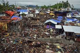
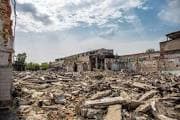
One of the biggest disaster management issues is assessing damages and their impact over time. Remote sensing data and GIS solve this problem by providing historical context. Time-series imaging lets authorities quantify natural resource, building, and infrastructure damage by comparing pre- and post-disaster circumstances. This data aids recovery and identifies disaster-prone locations.
Disaster management requires remote sensing and GIS mapping. Accurate and thorough geographical representations of disaster-affected areas enable visual knowledge, analysis, and decision-making. Remote sensing and GIS for disaster management mapping:
Spatial Representation: Disaster-affected regions are mapped using remote sensing data like satellite images, aerial photography, or LiDAR (Light Detection and Ranging). These data sources contain high-resolution, current land surface, infrastructure, and natural environment data. GIS software correctly depicts the disaster's impact by processing and interpreting these data.
Mapping helps estimate disaster damage. GIS tools help assess building, infrastructure, and environmental damage by overlaying pre- and post-disaster imagery. Damage assessment maps show destruction, aiding reaction and rehabilitation. This prioritizes resource allocation, aid, and reconstruction and rehabilitation.
Infrastructure Mapping: Mapping helps detect disaster-damaged infrastructure. Remote sensing and GIS can map damaged bridges, roads, power lines, and other infrastructure assets. Emergency response teams use this information to plan routes, distribute resources, and protect communities. Infrastructure mapping also aids disaster recovery.
Maps help identify and visualize emergency evacuation routes. GIS integrates geographical data including population density, road networks, and hazard zones to create evacuation route maps. These maps help authorities choose safe, effective evacuation routes based on traffic congestion, road accessibility, and shelter availability. Map evacuation routes to find bottlenecks and risks.
Satellite imaging and GIS can spot building collapses, road network damage, and landslides and ground movements following a major earthquake. Repeated satellite passes and remote sensing data enable long-term recovery plans by following reconstruction and rehabilitation.
Remote sensing and GIS in disaster management have improved decision-making, preparedness, response, and recovery. These technologies can help us construct more resilient societies and reduce disaster damage to humans and nature. Remote sensing and GIS will improve catastrophe management as technology advances, preparing our communities for an unpredictable future.
In conclusion, the amalgamation of remote sensing and Geographic Information Systems (GIS) has brought about a significant transformation in the realm of disaster management. These technologies are of utmost importance in the surveillance, cartography, and evaluation of the magnitude of destruction resulting from calamities.
By means of ongoing surveillance, remote sensing data enables the timely identification of potential hazards, facilitating prompt response and preparedness actions. Geographic Information Systems (GIS) play a crucial role in enabling the generation of precise and comprehensive maps that illustrate the spatial arrangement and consequences of calamities, thereby assisting in the process of decision-making and allocation of resources. Moreover, the analysis of data collected before and after a disaster allows for the measurement and assessment of the extent of damages over a specific period, thus offering significant insights that can inform and guide recovery and rehabilitation endeavors.
The utilization of remote sensing and Geographic Information Systems (GIS) contributes to an in-depth comprehension of various phenomena, thereby augmenting situational awareness, facilitating efficient coordination of response efforts, and bolstering the development of long-term recovery strategies. Through the utilization of these technologies, it is possible to mitigate the adverse effects of disasters on communities, infrastructure, and the environment.
The ongoing progression of technology will maintain the significance of remote sensing and geographic information systems (GIS) in the field of disaster management. Through the utilization of their capabilities, it is possible to construct communities that are more resistant to adverse circumstances, reduce the likelihood of potential hazards, and ultimately preserve human lives. The exploration of remote sensing and Geographic Information Systems (GIS) holds significant importance in unlocking novel prospects for enhancing global disaster preparedness, response, and recovery.
Cover Image Source: National Institute of Environmental Health Sciences