Sign up or log in to your Spatialnode account.

Takes less than a few seconds.

3D Topography Timor (Kupang Area)

Rasnanda
Rasnanda•

January 17, 2024

3D Topography Timor (Kupang Area)

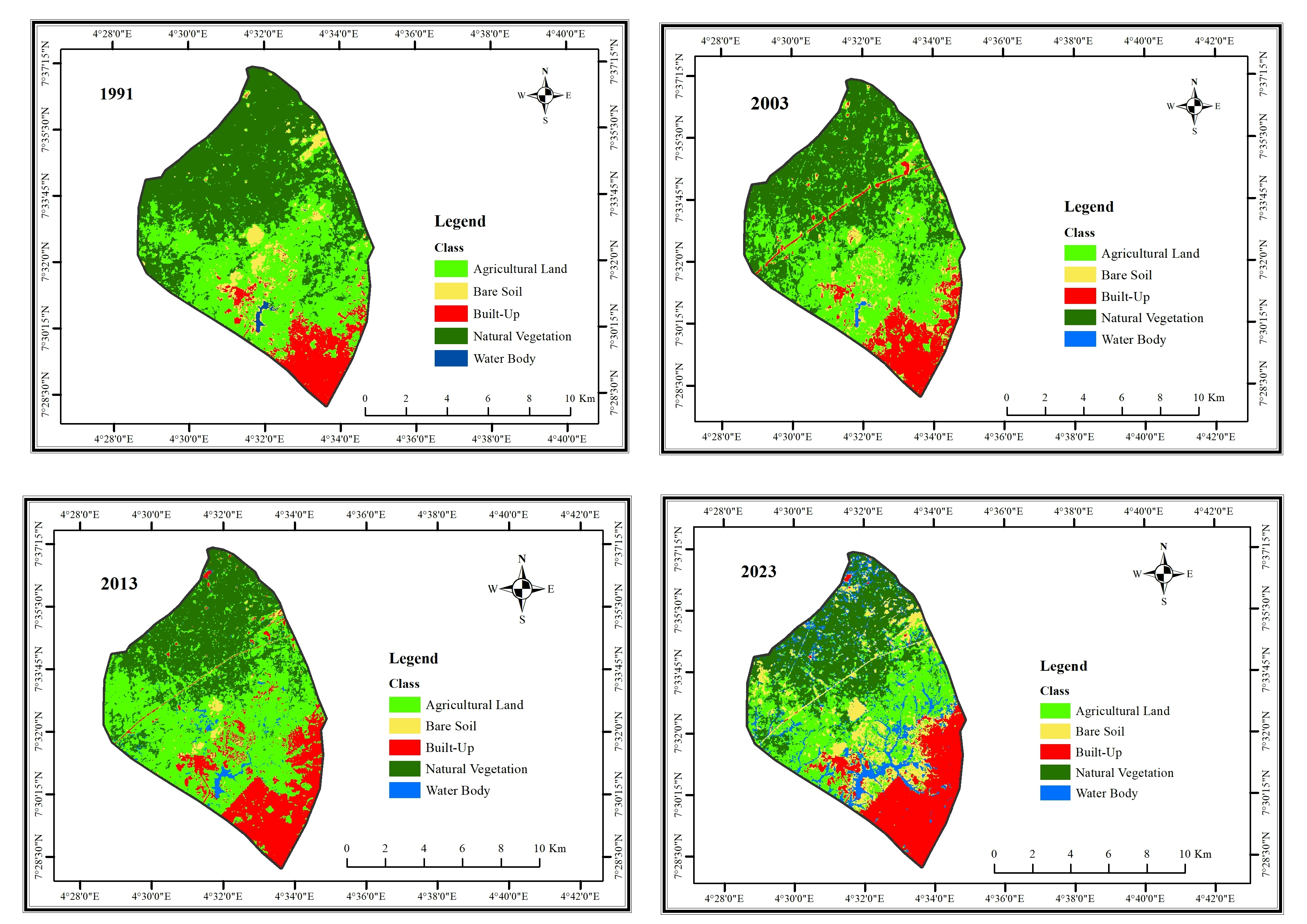
3D Topography Timor (Kupang Area) using qgis2threejs plugin


Plug-ins used

Qgis2threejs

tags

topographic map

More by Rasnanda

Webmap Isochrone Jawa
14
Isochrone Map of Palangkaraya
15
Flood Hazard Map of Palangkaraya
17
Isochrone map of Kupang
10
Persil (Landplot) Map
32

You might also like

Top 10 Most Multicultural Cities
Ria Rathod
Top 10 Most Multicultural Cities
Ria Rathod
43
Mapa vintage sec XVII Sergipe
Aristoteles Fernandes da Silva Filho
Mapa vintage sec XVII Sergipe
Aristoteles Fernandes...
16
How to Measure Land Use Mix via Entropy
Stewart Berry
How to Measure Land Use Mix via Entropy
Stewart Berry
322
Massacres in Latin America, 2018-2022
Sebastian Silva
Massacres in Latin America, 2018-2022
Sebastian Silva
99
Land Cover Maps
Ananda Rianti Dewi
Land Cover Maps
Ananda Rianti Dewi
11
MUNICÍPIO DE BELÉM EM 1988
Mapa_Geo
MUNICÍPIO DE BELÉM EM 1988
Mapa_Geo
41
Mapa de Localização
Fenando Paulo Neto Alberto
Mapa de Localização
Fenando Paulo...
38
LULLC Map of Ife South LGA
Oladeji Muhammed
LULLC Map of Ife South LGA
Oladeji Muhammed
154
Uso e Ocupação da Bacia do Rio Tietê
Matheus Sá
Uso e Ocupação da Bacia do Rio Tietê
Matheus Sá
6
2019-2023 Global Covid-19 Dashboard
Oladeji Muhammed
2019-2023 Global Covid-19 Dashboard
Oladeji Muhammed
28
Distribution of Caridina species
Philip Russo
Distribution of Caridina species
Philip Russo
455
Simulator database: Nordkapp-Hammerfest
Kareen Bröker
Simulator database: Nordkapp-Hammerfest
Kareen Bröker
55

Join the community!

We're a place where geospatial professionals showcase their works and discover opportunities.

Sign Up for free