Sign up or log in to your Spatialnode account.

Takes less than a few seconds.

MAPA DAS REGIÕES IMEDIATAS DA PARAÍBA

Jonatha Iuri
Jonatha Iuri•

December 28, 2022

MAPA DAS REGIÕES IMEDIATAS DA PARAÍBA

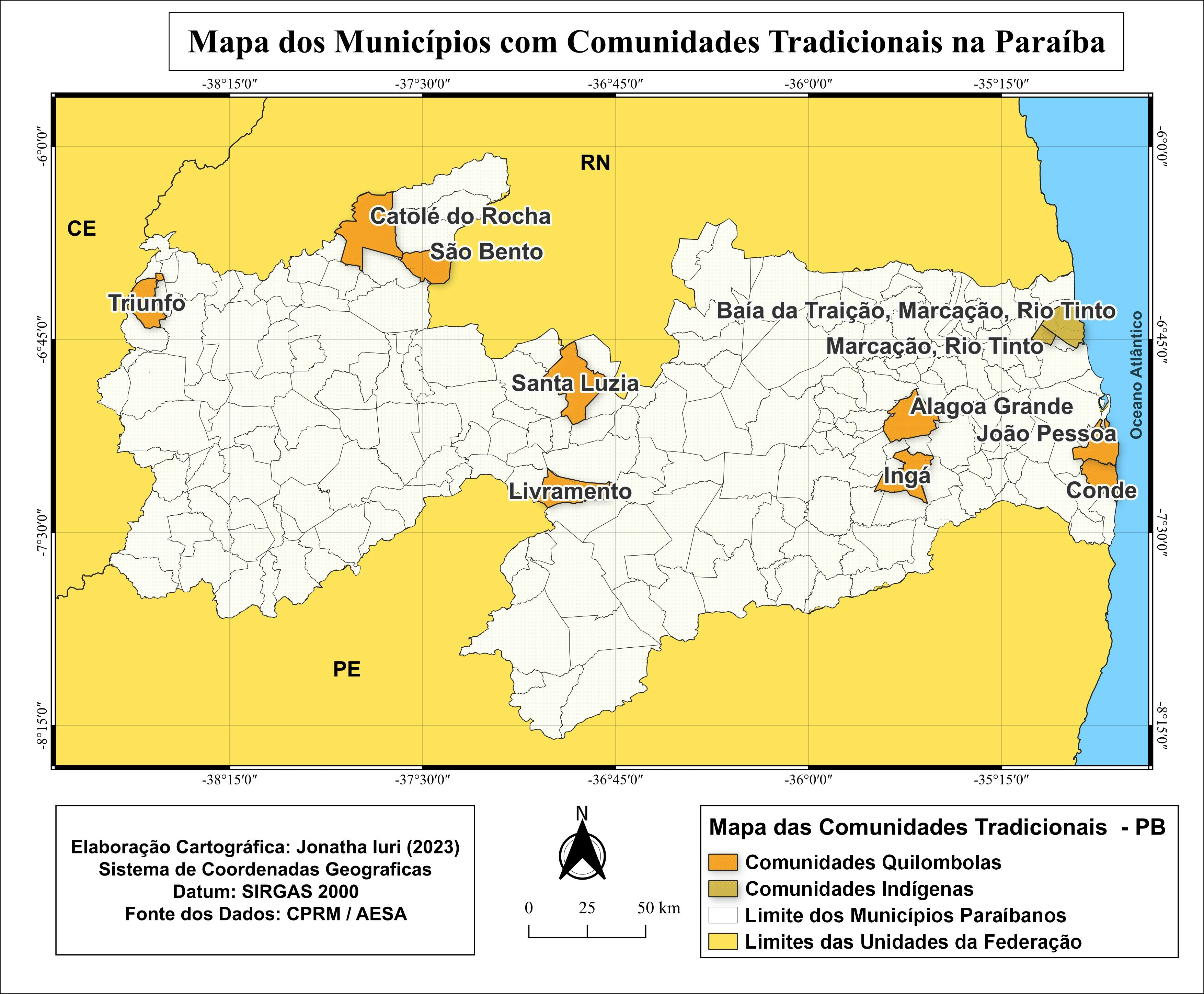
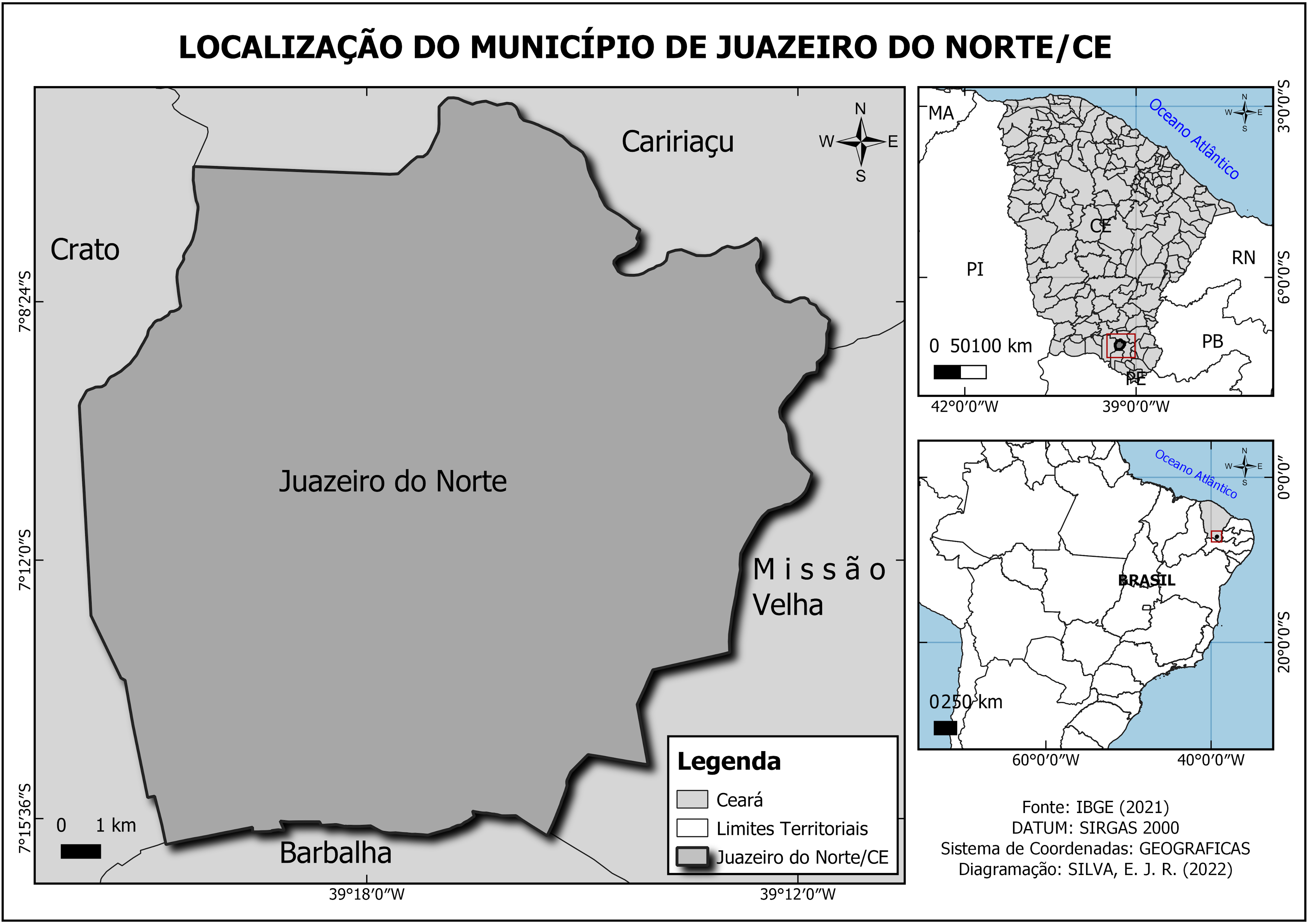
Mapa das regiões imediatas do Estado da Paraíba


Tools used

QGIS

Plug-ins used

HCMGIS

tags

brasilGISMAPAmapatematico#Paraíba

More by Jonatha Iuri

MAPA DAS REGIÕES INTERMEDIÁRIAS PARAÍBA
70
MAPA DOS BIOMAS DO BRASIL
15
MAPA DOS TIPOS DE SOLOS DE UIRAÚNA
36
MAPA DE LOCALIZAÇÃO DE UIRAÚNA/PB
145
Mapa do município de Joca Claudino/PB
42
MAPA DE LOCALIZAÇÃO DE UIRAÚNA/PB
310
MAPA DOS ABALOS SÍSMICOS DE UIRAÚNA/PB
12
MAPA MULTIESCALAR DE LOCALIZAÇÃO UIRAÚNA
94
MAPA DE LOCALIZAÇÃO ESCOLA-CAMPO / PB
12
MAPA DAS ASDs DO ESTADO DA PARAÍBA
17
MAPA GEOLÓGICO DO MUNICÍPIO DE UIRAÚNA
10
Mapa dos municípios comunidades tr da PB
42

You might also like

Komodo Island Tourism Map
Dian Rizky
Komodo Island Tourism Map
Dian Rizky
45
Proposta de corredor ecológico
Guilherme Herculano de Oliveira
Proposta de corredor ecológico
Guilherme Herculano...
15
3a: Demographics and Health in Illinois
Patrick Ansell
3a: Demographics and Health in Illinois
Patrick Ansell
7
Jefferson County Tax Income
Sean Willis
Jefferson County Tax Income
Sean Willis
57
ANALYSIS OF LAKE NAKURU NDWI LANDSAT 8
MOSES MWANIA MULYUNGI
ANALYSIS OF LAKE NAKURU NDWI LANDSAT 8
MOSES MWANIA MULYUNGI
15
APP hídrica demarcadas em dois períodos
Poliana Marilia da Silva Mello Betella dos Santos
APP hídrica demarcadas em dois períodos
Poliana Marilia...
16
Intervenções e Georreferenciamento
Mauricio Matheus
Intervenções e Georreferenciamento
Mauricio Matheus
13
Hipsometria divisas
MICHAEL LUCAS DA SILVA SA
Hipsometria divisas
MICHAEL LUCAS...
86
Least Cost Path Hiking Trail Improvement
Colin Young
Least Cost Path Hiking Trail Improvement
Colin YoungPro
10
Mapa de Temperatura Superficial
RODRIGO DE ARAUJO BELOTE
Mapa de Temperatura Superficial
RODRIGO DE...
17
Data Center Placement in N. Virginia
Maddy Peck
Data Center Placement in N. Virginia
Maddy Peck
4
Estimating Canopy Height from LiDAR
Joe Pitti
Estimating Canopy Height from LiDAR
Joe Pitti
9

Join the community!

We're a place where geospatial professionals showcase their works and discover opportunities.

Sign Up for free