Sign up or log in to your Spatialnode account.

Takes less than a few seconds.

MAPA DAS REGIÕES INTERMEDIÁRIAS PARAÍBA

Jonatha Iuri
Jonatha Iuri•

December 28, 2022

MAPA DAS REGIÕES INTERMEDIÁRIAS PARAÍBA

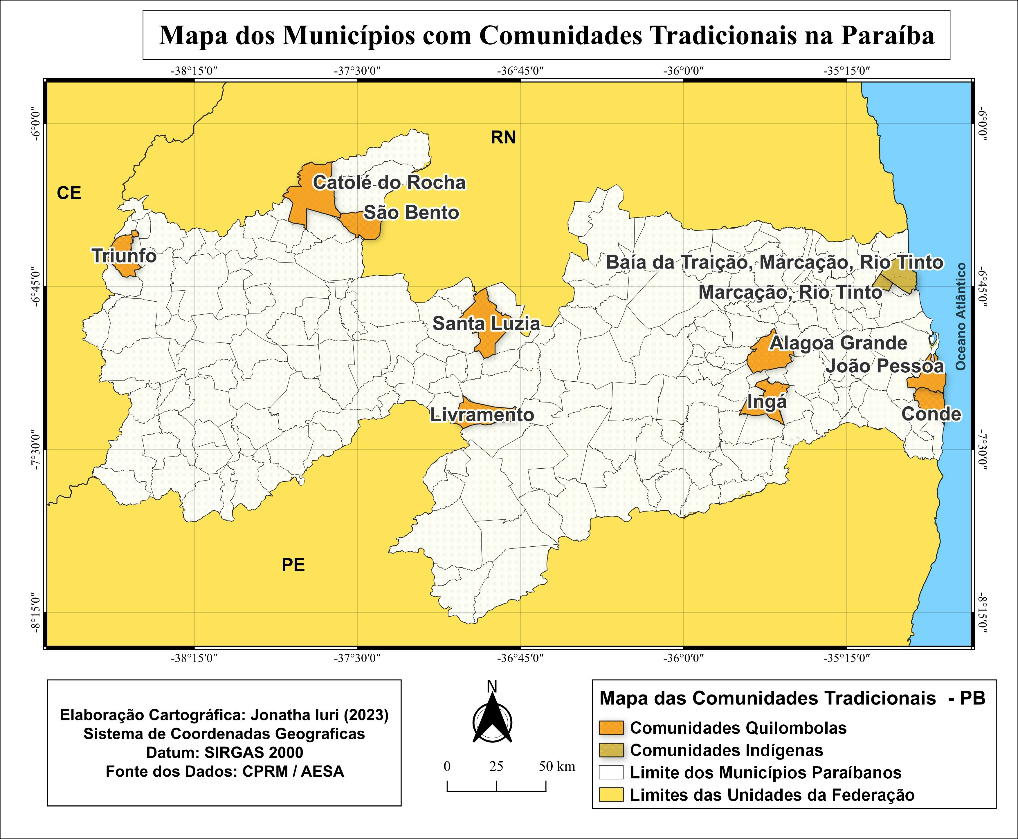
Mapa das regiões intermediárias da Paraíba após a mudança do IBGE em 2017


Tools used

QGIS

Plug-ins used

hc

tags

brasilMAPAmapatematicoQGISsig

More by Jonatha Iuri

MAPA MULTIESCALAR DE LOCALIZAÇÃO UIRAÚNA
96
MAPA DE LOCALIZAÇÃO DE UIRAÚNA/PB
158
Mapa dos municípios comunidades tr da PB
47
MAPA DOS TIPOS DE SOLOS DE UIRAÚNA
40
MAPA DAS MACRORREGIOES DO BRASIL
53
MAPA DOS ABALOS SÍSMICOS DE UIRAÚNA/PB
13
MAPA DAS ASDs DO ESTADO DA PARAÍBA
21
MAPA DE LOCALIZAÇÃO ESCOLA-CAMPO / PB
12
MAPA DAS REGIÕES IMEDIATAS DA PARAÍBA
486
MAPA HIPSOMÉTRICO DA CIDADE DE UIRAÚNA
29
Mapa do município de Joca Claudino/PB
51
MAPA DOS BIOMAS DO BRASIL
17

You might also like

Focos de Queimadas em Altamira - PA
Jardel Estevam Barbosa dos Santos
Focos de Queimadas em Altamira - PA
Jardel Estevam...
7
Know Your Lagos Market.
Chinazo Anebelundu
Know Your Lagos Market.
Chinazo Anebelundu
440
Environmental Justice in Mitigation
Simone Chapman
Environmental Justice in Mitigation
Simone Chapman
140
StoryMap - Floodplain Land Use
Sherri Michl
StoryMap - Floodplain Land Use
Sherri Michl
90
Manhattan Storm Surges
Ria Rathod
Manhattan Storm Surges
Ria Rathod
11
Roughness
Adam O Dolce
Roughness
Adam O Dolce
42
Ski slope suitability model
Katalin Peter
Ski slope suitability model
Katalin Peter
23
Número de cadastros nas UBS
Priscila Andreza dos Santos Buarque
Número de cadastros nas UBS
Priscila Andreza...
8
Carbonate Morphology
Adi Neuman
Carbonate Morphology
Adi Neuman
10
TRENDS IN ATMOSPHERIC CO2
Temidayo Fabiyi
TRENDS IN ATMOSPHERIC CO2
Temidayo Fabiyi
12
DEM Data for Virginia farm
Cari Lynn Squibb
DEM Data for Virginia farm
Cari Lynn Squibb
40
LULC and Wind direction map.
Oswald Onimhawo
LULC and Wind direction map.
Oswald Onimhawo
23

Join the community!

We're a place where geospatial professionals showcase their works and discover opportunities.

Sign Up for free