Introduction
In the context of Niger Republic, land surface temperature (LST) refers to the degree of hotness or coldness that can be felt from the Earth's surface in any location within the country. It can also be defined as the radiative skin temperature of the land surface. LST is a combination of temperatures from vegetation and bare soil. Both of these elements respond quickly to changes in incoming solar radiation due to cloud cover, aerosol load modifications, and diurnal variations in illumination. As a result, the land surface temperature in Niger Republic exhibits rapid fluctuations. This temperature, in turn, influences the distribution of energy between the ground and vegetation, ultimately determining the surface air temperature in the region.
Study Area
The Republic of Niger is a landlocked country located in West Africa, bordered by Algeria, Libya, Chad, Nigeria, Benin, Burkina Faso, and Mali. Niger has a diverse landscape that includes parts of the Sahara Desert, the Sahel, and savannah regions. The country has an estimated population of about 24 million people, with the majority living in rural areas and engaged in farming and livestock activities. The climate in Niger is predominantly hot and dry, with significant variations in temperature between day and night. Over the years, there has been a gradual increase in urbanization and development, especially in the capital city, Niamey.
Materials
The dataset used for this study is Landsat 8 Level 1 satellite imagery. Google Earth Engine was utilized for processing the satellite data, and QGIS was employed for designing the map.
Result
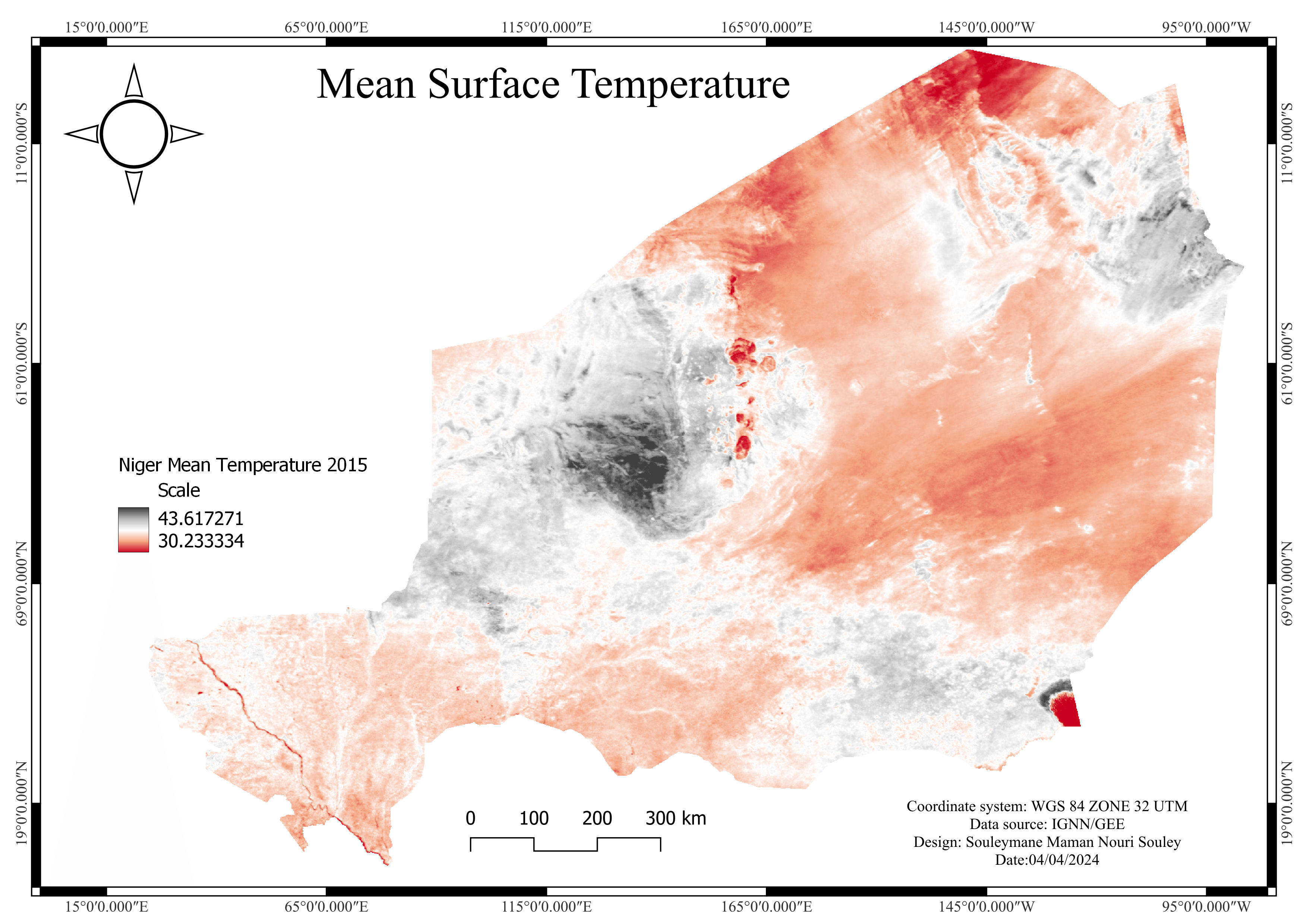
The map shows that the land surface temperature over Niger Republic in January 2015 varies from 31 degrees Celsius to 44 degrees Celsius. In the map, the maximum temperatures are represented by black, highlighting the desert areas in the northern part of the country where these higher temperatures are recorded. The minimum temperatures are depicted in red, indicating cooler areas in the western, southern, and eastern parts of Niger Republic. This color gradient illustrates a significant temperature contrast across the country, with the northern desert regions being the hottest and the other regions being relatively cooler.
Conclusion
This project demonstrates that the highest land surface temperatures in Niger Republic are associated with the desert regions in the northern part of the country. The map illustrates that these areas, depicted in black, experience the highest temperatures, while the western, southern, and eastern regions, shown in red, have lower temperatures. This project highlights the significant temperature contrast across Niger Republic, with the northern desert areas being notably hotter compared to the cooler regions in other parts of the country. This variation underscores the influence of geographic and climatic factors on land surface temperatures.
Skills Demonstrate
- Cloud dataset (Google Earth Engine) analysis
- Satellite remote sensing and data analysis
- Data visualization and interpretation
- QGIS software proficiency