Introduction
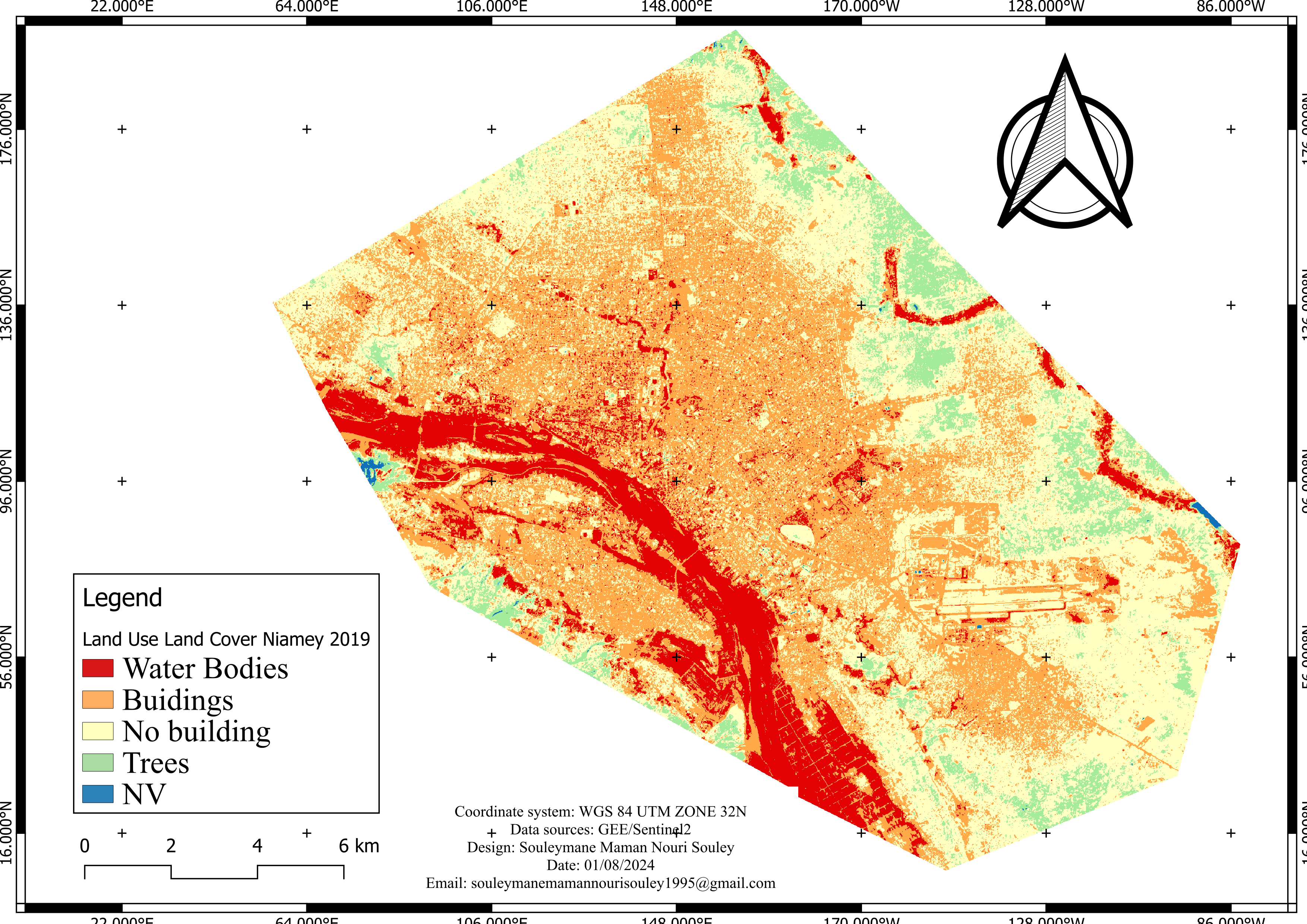
In the context of Niamey, Niger Republic, land use land cover (LULC) refers to the various ways in which the land is utilized and covered within the city. It encompasses different categories such as buildings, water bodies, trees, and non-vegetated areas. Understanding LULC is crucial for urban planning, resource management, and environmental monitoring. This study utilizes Sentinel-2 satellite imagery processed in Google Earth Engine and visualized using QGIS to map the LULC of Niamey for the year 2019.
Objectives
To classify and map the land use and land cover of Niamey using Sentinel-2 satellite imagery.
To analyze the extent and distribution of urbanization in Niamey.
To identify and quantify different land cover types including buildings, water bodies, trees, and non-vegetated areas.
To utilize Google Earth Engine for efficient processing and classification of satellite data.
To design and visualize the LULC map using QGIS for better interpretation and presentation.
To provide valuable insights for urban planning and environmental management in Niamey.
Study Area
Niamey, the capital city of Niger Republic, is situated in West Africa. It is bordered by Algeria, Libya, Chad, Nigeria, Benin, Burkina Faso, and Mali. The city lies on the banks of the Niger River and has a rapidly growing population due to urbanization and development. Niamey experiences a hot and dry climate, with significant temperature variations between day and night. The diverse landscape includes urban areas, agricultural lands, and natural vegetation, which are crucial for the livelihoods of the residents.
Materials
The dataset used for this study is Sentinel-2 satellite imagery. Google Earth Engine (GEE) was utilized for processing the satellite data, and QGIS was employed for designing the LULC map.
Methodology
Data Acquisition: Sentinel-2 satellite imagery for Niamey for the year 2019 was obtained.
Data Processing: The imagery was processed in Google Earth Engine to classify different land cover types.
Map Design: The classified data was imported into QGIS for map layout design and visualization.
Result
The LULC map of Niamey for 2019 reveals the distribution of various land cover types within the city. The map categorizes the land cover into five classes: water bodies, buildings, no building areas, trees, and non-values (NV) areas.
Water Bodies: Represented in blue, these areas include the Niger River and other smaller water bodies within the city.
Buildings: Marked in red, indicating the densely built-up urban areas.
No Building: Shown in orange, representing areas without buildings, likely including open spaces and undeveloped land.
Trees: Depicted in green, indicating vegetated areas with significant tree cover.
NV (Non-Value): Represented in light blue, these areas can include bare soil, rocky surfaces, and other non-vegetated land.
The map highlights the extensive urbanization in Niamey, with a significant portion of the city covered by buildings. The presence of water bodies and vegetated areas provides crucial ecological and recreational benefits to the urban environment.
Conclusion
This project demonstrates the application of Sentinel-2 satellite imagery and advanced processing techniques in Google Earth Engine and QGIS to map the LULC of Niamey, Niger Republic. The resulting map provides valuable insights into the distribution of different land cover types, which is essential for urban planning and environmental management. The map illustrates the extent of urbanization in Niamey, highlighting the need for sustainable development practices to balance growth with ecological preservation.


.jpeg&w=3840&q=75)

