Introduction
In the context of the Niger Republic, the Normalized Difference Vegetation Index (NDVI) is a crucial indicator of vegetation health and coverage. NDVI measures the difference between near-infrared (which vegetation strongly reflects) and red light (which vegetation absorbs). The values range from -1 to +1, where higher values indicate more dense and healthy vegetation. This metric is essential for understanding vegetation dynamics, land degradation, and ecological changes over time, especially in regions facing climate variability and human-induced impacts. In this study, we analyze the NDVI of Maradi, one of the largest regions in Niger, to assess changes in vegetation health between 2021 and 2024.
Study Area
The Republic of Niger is a landlocked country in West Africa, bordered by Algeria, Libya, Chad, Nigeria, Benin, Burkina Faso, and Mali. The Maradi region, located in the southern part of Niger, is known for its agricultural activities, which are vital for the country's food security. The region's climate is predominantly semi-arid, with a short rainy season and a long dry season. This climatic condition makes Maradi particularly sensitive to environmental changes and necessitates continuous monitoring of its vegetation health.
Materials
The datasets used for this study include NDVI data derived from Sentinel-2 satellite imagery, processed using Google Earth Engine (GEE). The spatial analysis and map design were performed using QGIS software. The NDVI maps for the years 2021 and 2024 were created to visualize and compare vegetation health over time.
Results
The attached map illustrates the NDVI values for Maradi in 2021 and 2024, alongside the difference in NDVI values between these years.
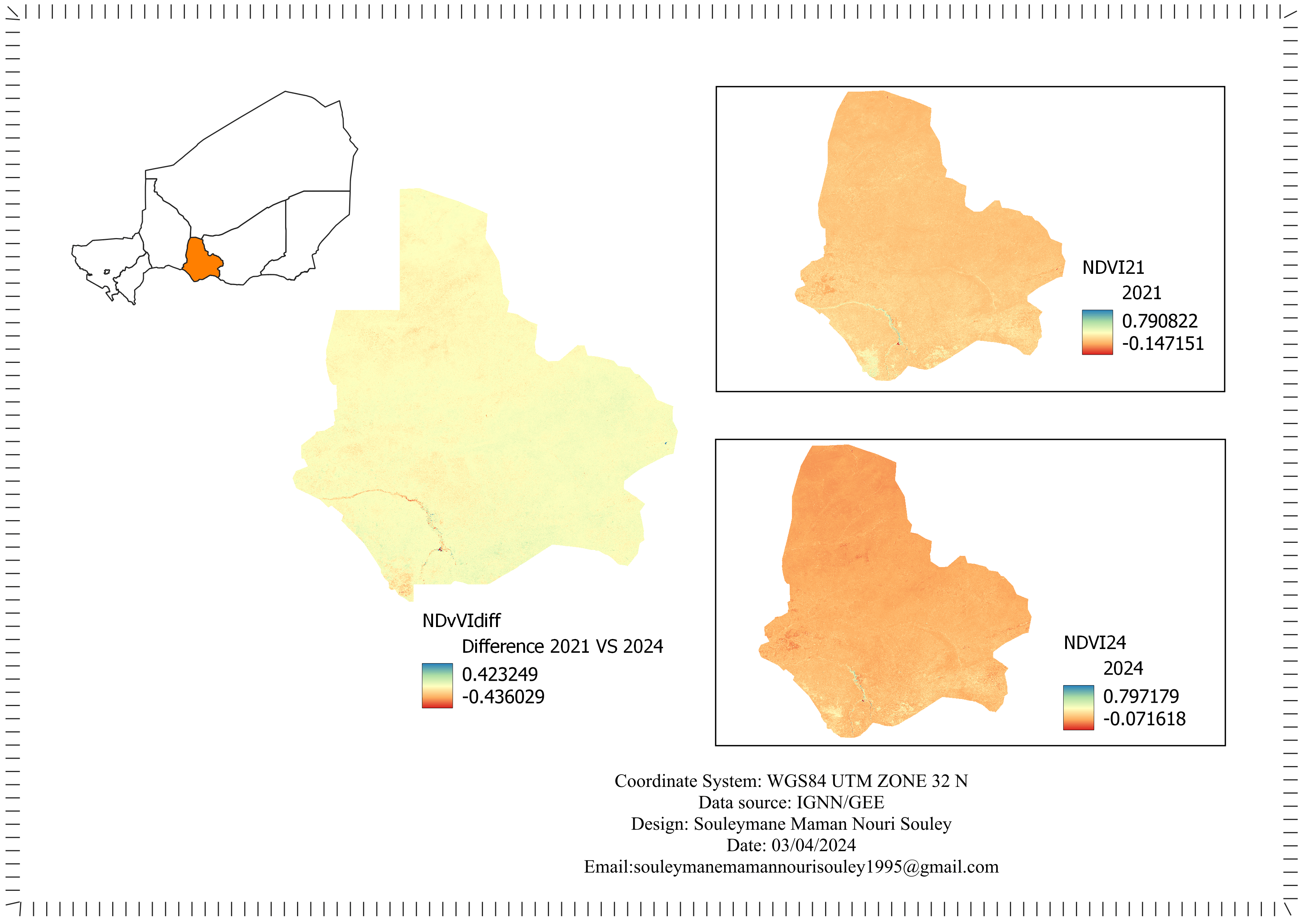
NDVI 2021: This map shows the distribution of NDVI values in Maradi for the year 2021. The NDVI values range from -0.147151 to 0.790822, indicating variations in vegetation health across the region.
NDVI 2024: This map depicts the NDVI values for Maradi in 2024. The NDVI values range from -0.071618 to 0.797179, reflecting changes in vegetation coverage and health over the three-year period.
NDVI Difference (2021 vs. 2024): This map highlights the difference in NDVI values between 2021 and 2024. The difference ranges from -0.436029 to 0.423249, showing areas of vegetation loss (negative values) and gain (positive values).
Conclusion
The analysis of NDVI in Maradi over the period from 2021 to 2024 reveals significant changes in vegetation health and coverage. The observed variations highlight the dynamic nature of the region's vegetation, influenced by climatic conditions and possibly human activities. Continuous monitoring using NDVI can provide valuable insights for sustainable land management and conservation efforts in Maradi and similar regions in Niger.
Skills Demonstrated
Cloud dataset (Google Earth Engine) analysis
Satellite remote sensing and data analysis
Data visualization and interpretation
QGIS software proficiency
This project underscores the importance of remote sensing and GIS tools in monitoring environmental changes and guiding decision-making for sustainable development in vulnerable regions like Maradi.