Sign up or log in to your Spatialnode account.

Takes less than a few seconds.

BARINGO COUNTY PROPOSED CONSERVANCIES

John Wahome Gathoni
John Wahome Gathoni•

January 31, 2022

BARINGO COUNTY PROPOSED CONSERVANCIES

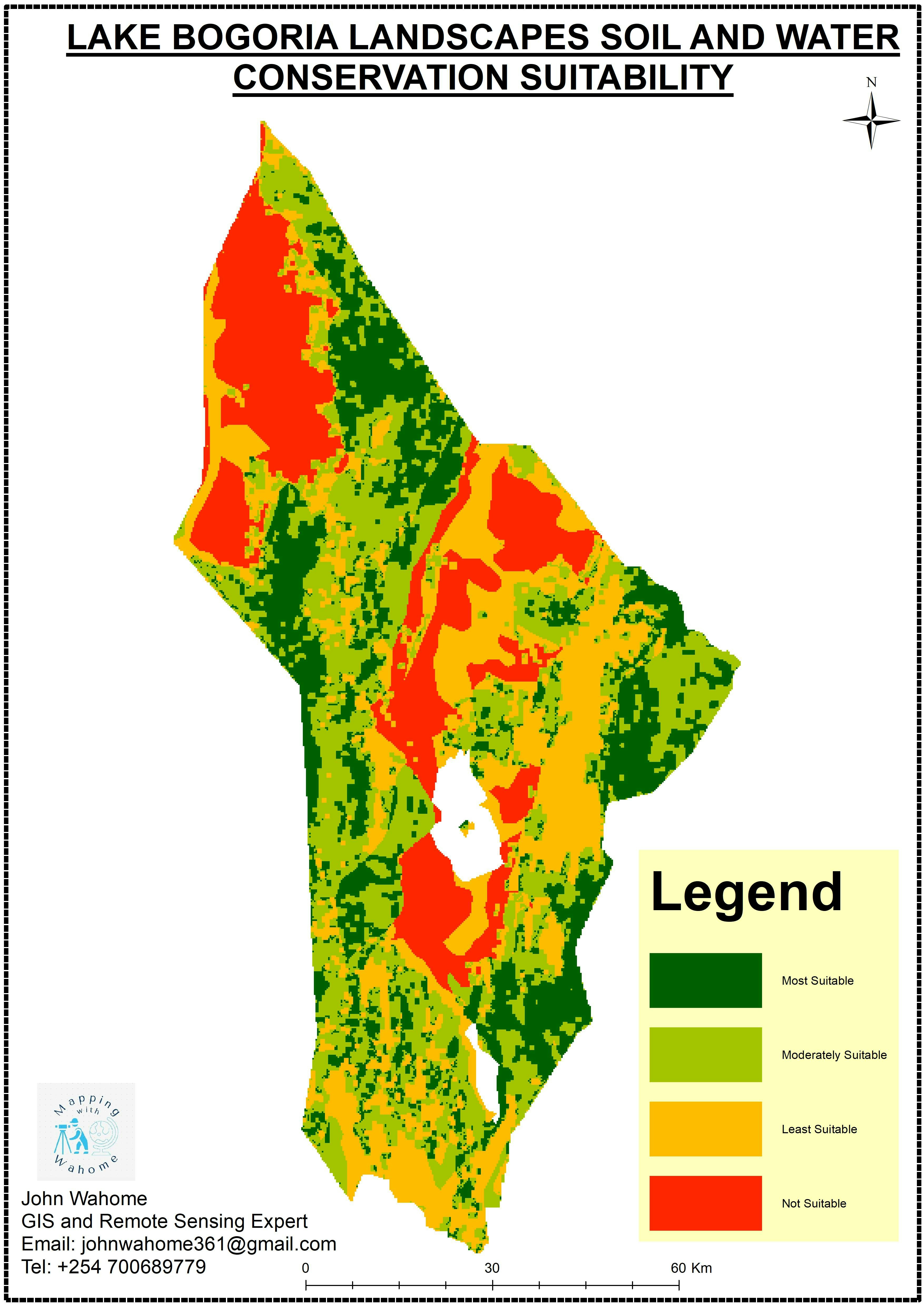
Mapping proposed conservancies in Baringo.


Tools used

ArcMap

Plug-ins used

Google Earth Engine(GEE)

tags

ArcMap

More by John Wahome Gathoni

Mombasa Tourist Guiding System
323
KERIO VALLEY AGROECOLOGICAL ZONES, Kenya
95
KENYA ESRI LULC 2020
114
Health Centres in Kenya
21
KERIO VALLEY SOIL LOSS USING RUSLE
99
GEOHAZARD RISK ZONES ANALYSIS
101
UHURU PARK LOCATION-NAIROBI, KENYA
68
Soil and water conservation Suitability
72
Find the Nearest Health Centre
23
Monochrome Map
Monochrome Map
16
TANYAI FOREST LOSS ANALYSIS(1990-2020)
150

You might also like

Drought and Snowpack in California
Colin Kippe
Drought and Snowpack in California
Colin KippePro
11
Explorando as alturas da Serra de SAGA
Gabriel Henrique Braga Matos
Explorando as alturas da Serra de SAGA
Gabriel Henrique...
30
Mapa de Área de Preservação Permanente
Mauricio Matheus
Mapa de Área de Preservação Permanente
Mauricio Matheus
38
BCI 50ha Plot Tree Species Distribution
Milton Solano Sequeira
BCI 50ha Plot Tree Species Distribution
Milton Solano Sequeira
53
Geocoding and Network Analysis
Kamille Mendoza
Geocoding and Network Analysis
Kamille Mendoza
22
Allendale Lot Design
Cole Feyen
Allendale Lot Design
Cole Feyen
15
Mapa analítico/ Analytical map
Ronald Noutcheu
Mapa analítico/ Analytical map
Ronald Noutcheu
13
Bairros, Regiões de Londrina
WILLIAN S. SANTOS 🇧🇷
Bairros, Regiões de Londrina
WILLIAN S....
2.6K
MAPA DE USO E COBERTURA VEGETAL
Gustavo da Silva Francisco
MAPA DE USO E COBERTURA VEGETAL
Gustavo da...
27
Various soil varieties in Nigeria
Abiona Olushola
Various soil varieties in Nigeria
Abiona Olushola
25
Composição Landsat 8
Sidney dos Santos
Composição Landsat 8
Sidney dos Santos
98
Municípios  de Minas Gerais por área
Lucas de Siqueira Cardinelli
Municípios de Minas Gerais por área
Lucas de...
54

Join the community!

We're a place where geospatial professionals showcase their works and discover opportunities.

Sign Up for free