Sign up or log in to your Spatialnode account.

Takes less than a few seconds.

GEOHAZARD RISK ZONES ANALYSIS

John Wahome Gathoni
John Wahome Gathoni•

January 31, 2022

GEOHAZARD RISK ZONES ANALYSIS

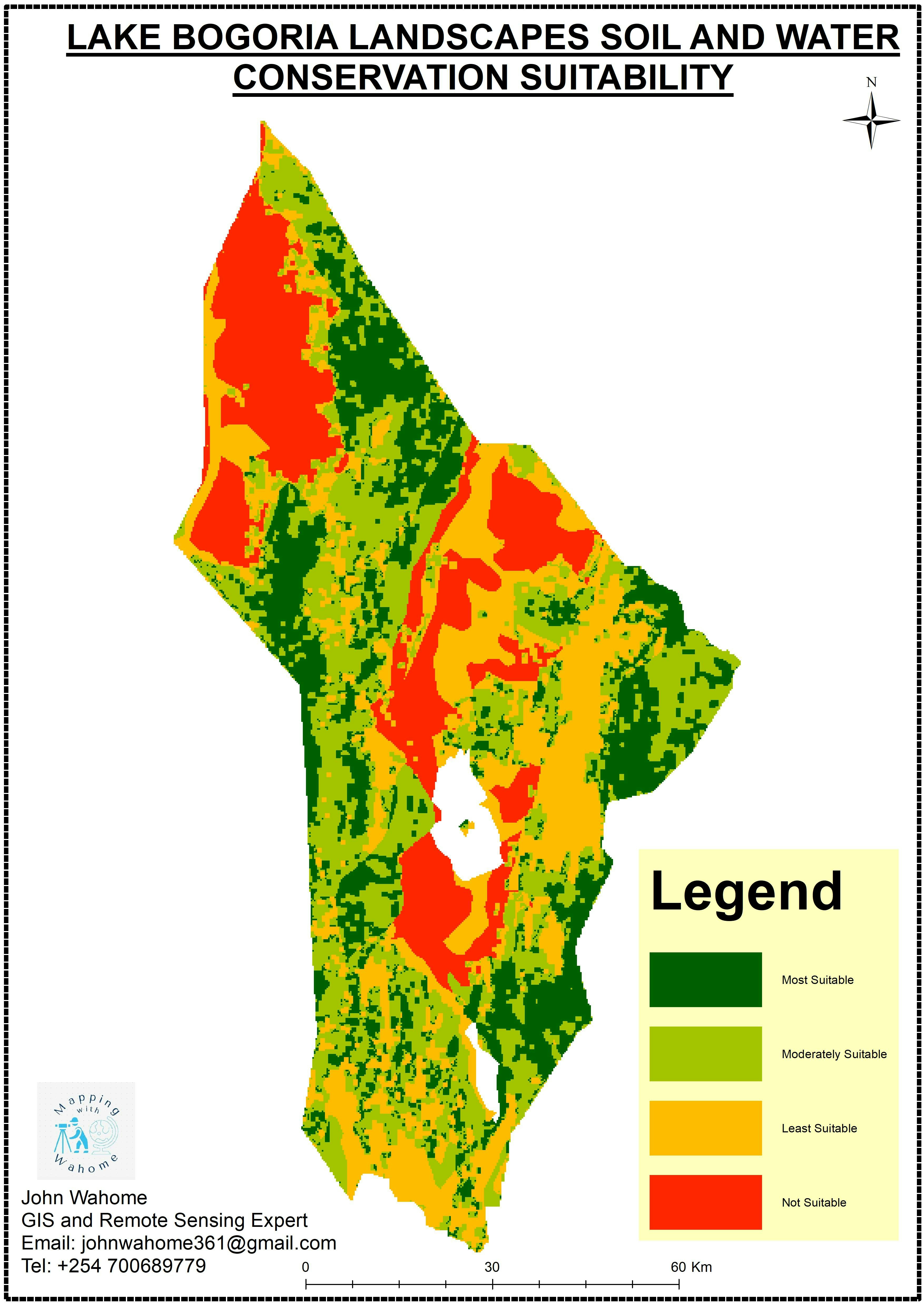
An analysis of the geohazard risk zones in Kerio Valley that was done using Analytical Hierarchical process (AHP) plugin in Arcmap.


Tools used

ArcMap

Plug-ins used

ArcMap

tags

ArcMap

More by John Wahome Gathoni

Mombasa Tourist Guiding System
323
UHURU PARK LOCATION-NAIROBI, KENYA
68
Find the Nearest Health Centre
23
KENYA ESRI LULC 2020
114
BARINGO COUNTY PROPOSED CONSERVANCIES
99
TANYAI FOREST LOSS ANALYSIS(1990-2020)
150
Soil and water conservation Suitability
72
Monochrome Map
Monochrome Map
16
KERIO VALLEY AGROECOLOGICAL ZONES, Kenya
95
Health Centres in Kenya
21
KERIO VALLEY SOIL LOSS USING RUSLE
99

You might also like

Academic exercise for text placement
Sherri Michl
Academic exercise for text placement
Sherri Michl
13
Foz do rio Piranhas-Açu
Jardel Estevam Barbosa dos Santos
Foz do rio Piranhas-Açu
Jardel Estevam...
26
Relative Elevation Model (REM)
Adriana Calderon
Relative Elevation Model (REM)
Adriana Calderon
634
ÍNDICE DE VULNERABILIDADE SOCIOAMBIENTAL
Francielle Caminhas
ÍNDICE DE VULNERABILIDADE SOCIOAMBIENTAL
Francielle Caminhas
13
Calculo de NDVI
Eliezer Lucio Fernandes Lima
Calculo de NDVI
Eliezer Lucio...
16
Seasonal Change, Colorado
Sammer
Seasonal Change, Colorado
Sammer
21
Vegetação e Áreas Protegidas do Cerrado
Murilo Silva
Vegetação e Áreas Protegidas do Cerrado
Murilo Silva
15
Projected Time Zones 🌐
Alexa Cristina
Projected Time Zones 🌐
Alexa Cristina
41
Classificação de Horton-Strahler
Matheus Amaral Prates
Classificação de Horton-Strahler
Matheus Amaral Prates
28
Zanzibar location
Hashimu Misanya
Zanzibar location
Hashimu Misanya
29
Active fire in the last 7 days
Balogun Temitope
Active fire in the last 7 days
Balogun Temitope
347
State Wide Flow Map
Jesse Kato
State Wide Flow Map
Jesse Kato
29

Join the community!

We're a place where geospatial professionals showcase their works and discover opportunities.

Sign Up for free