
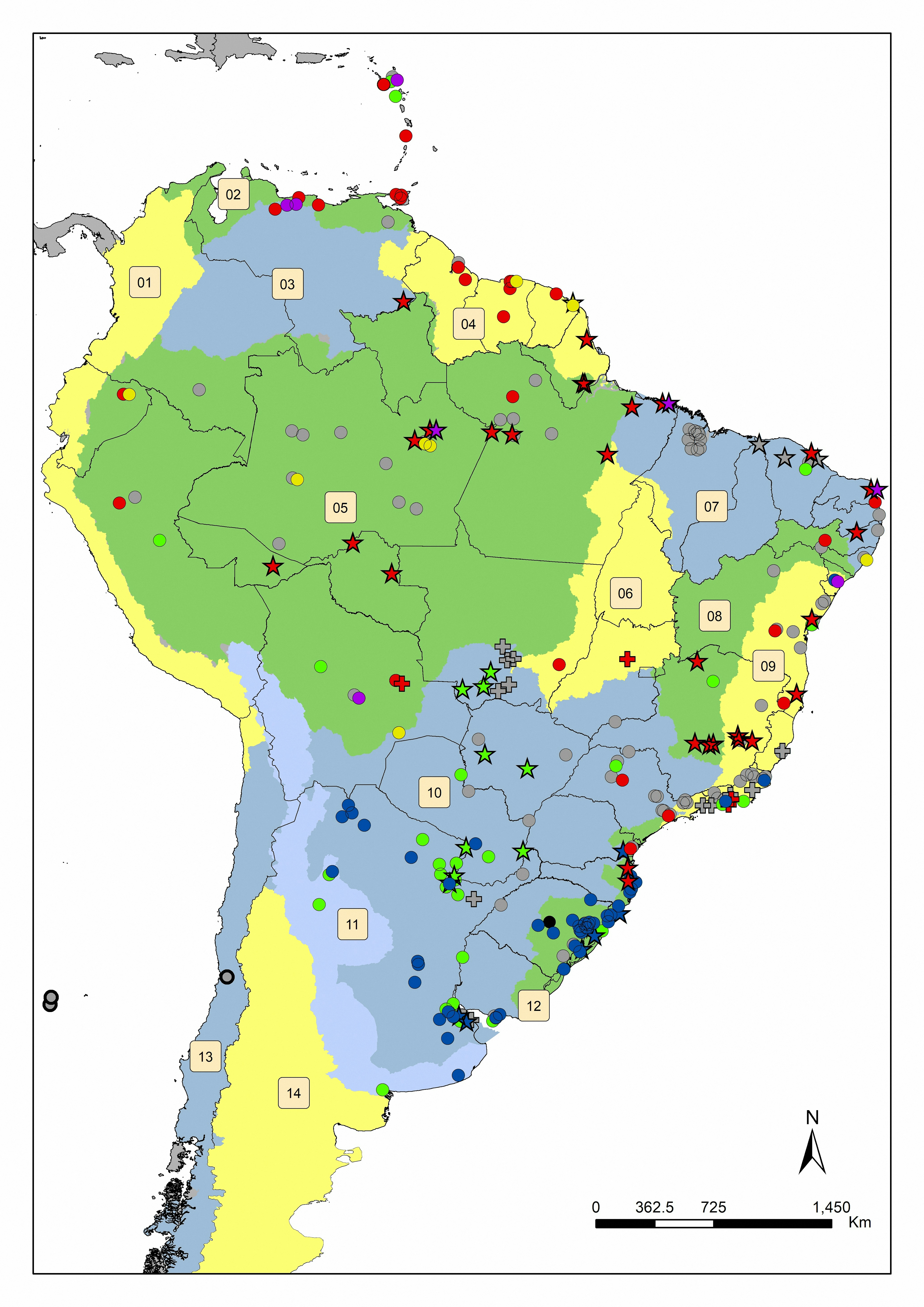
EN:Map indicating the distribution of the slugs Omalonyx species across Neotropical region at the hydrographic regions. The species records were represented by colours: red = O. matheroni; blue = O. convexus; green = O. unguis; yellow = O. geayi; purple = O. pattersonae; black = O. brasiliensis; gray = do not identified until species level, or Omalonyx sp.; gray circle with black border = Specimens not identified from Chile that were previously named erroneous as O. gayana. The stars represents new records made in the surveys of the work itself, the circles represents literature or museums data and the cross symbol represents the samples that were donated by other researchers. Hydrographic regions are indicated by: 1) Pacific Coast; 2) Caribbean sea; 3) Orinoco River; 4) Amapá-Esequibo; 5) Amazon River; 6) Tocantins River; 7) North Atlantic; 8) São Francisco River; 9) Eastern Atlantic; 10) Del Plata; 11) Border strip of the Brasilica (North) and the Chilean-Patagonian (South West) Subregion; 12) Eastern; 13) Chilean-Patagonian Subregion of the Pacific Versant; 14) Chilean-Patagonian Subregion of the Atlantic Versant. Map published at: http://dx.doi.org/10.1590/1676-0611-bn-2017-0409
PT:Mapa da distribuição das espécies de lesmas Omalonyx da região Neotropical nas regiões hidrográficas. Os registros das espécies foram representados por colores: vermelho = O. matheroni; azul = O. convexo; verde = O. unguis; amarelo = O. geayi; roxo = O. pattersonae; preto = O. brasiliensis; cinza = não identificado até o nível de espécie, ou Omalonyx sp.; círculo cinza com borda preta = espécimes não identificados do Chile que foram anteriormente nomeados erroneamente como O. gayana. As estrelas representam novos registros feitos nos levantamentos do próprio trabalho, os círculos representam dados da literatura ou de museus e as cruzes representam as amostras que foram doadas por outros pesquisadores. As regiões hidrográficas são indicadas por: 1) Costa do Pacífico; 2) Mar do Caribe; 3) Rio Orinoco; 4) Amapá-Esequibo; 5) Rio Amazonas; 6) Rio Tocantins; 7) Atlântico Norte; 8) Rio São Francisco; 9) Atlântico Leste; 10) Del Plata; 11) Faixa de fronteira da sub-região Brasilica (Norte) e Chileno-Patagônia (Sudoeste); 12) Oriental; 13) Sub-região Chilena-Patagônica do Versante do Pacífico; 14) Sub-região chileno-patagônica do Versante Atlântico. Mapa publicado em: http://dx.doi.org/10.1590/1676-0611-bn-2017-0409


.svg "Alec Soltes")


