Sign up or log in to your Spatialnode account.

Takes less than a few seconds.

Seasonal Deviation using CHIRPS data

Adriana Calderon
Adriana Calderon•

August 16, 2023

Seasonal Deviation using CHIRPS data

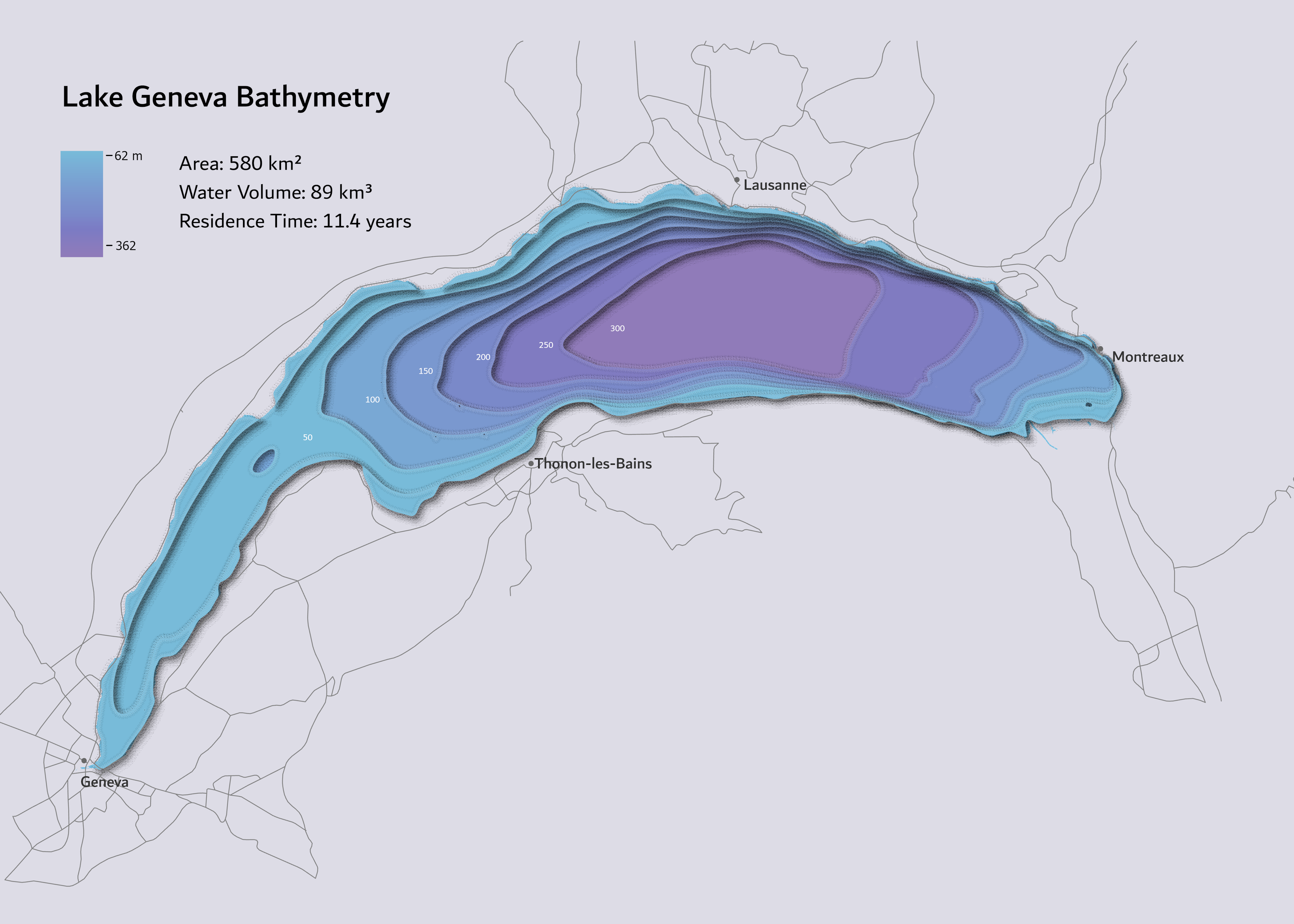
Rainfall Anomalies for the summer season 2023 compared to the seasonal historical average (1992 - 2020)


More by Adriana Calderon

Canopy Height Model, Selby, UK
93
Leeds City Centre in 3D
205
Interlaken with RayShader
25
Panama's River Network
309
Relative Elevation Model (REM)
623
Lord of The Rings Style
382
Aegean Islands
Aegean Islands
138
Panama 3D Population Density
216
La Yeguada Lagoon
La Yeguada Lagoon
44
Rain in Central America
22
Bathymetry of Lake Geneva
75
Geneva in Rayshader
Geneva in Rayshader
77

You might also like

Demographics of Egbeda LGA, Oyo state.
Favour Okikiri
Demographics of Egbeda LGA, Oyo state.
Favour Okikiri
63
Planta Cadastral da Faixa de Servidão
DOUGLAS HENRIQUE MANOEL PEREIRA
Planta Cadastral da Faixa de Servidão
DOUGLAS HENRIQUE...
25
Geochemical Map in Southwest, Nigeria
Emeka Ude
Geochemical Map in Southwest, Nigeria
Emeka Ude
21
Portos da América do Sul
Jardel Estevam Barbosa dos Santos
Portos da América do Sul
Jardel Estevam...
41
MN Forest Damage Causes
Nick Linell
MN Forest Damage Causes
Nick LinellPro
2
Mapa topográfico
Eduardo Nardez
Mapa topográfico
Eduardo Nardez
9
Comparing flood extents in Taquari River
Vinicius Kuchinski
Comparing flood extents in Taquari River
Vinicius Kuchinski
555
Focos de incêndio em Minas Gerais
Vitória Serra Bernardes
Focos de incêndio em Minas Gerais
Vitória Serra Bernardes
211
Geocoding and Environmental Justice
Yuxin (Sienna) He
Geocoding and Environmental Justice
Yuxin (Sienna) He
10
Oceans Map
Marica di Girolamo
Oceans Map
Marica di Girolamo
17
South Dakota Oil Fields
Keran Nkongolo
South Dakota Oil Fields
Keran NkongoloPro
10
MAP OF FARM OVERLAID ON CLASSIFIED IMAGE
Edidiong Ekrikpo
MAP OF FARM OVERLAID ON CLASSIFIED IMAGE
Edidiong Ekrikpo
6

Join the community!

We're a place where geospatial professionals showcase their works and discover opportunities.

Sign Up for free